You are here: Home > Network List > N4 - Central and EAstern US Network Stations List
> Station X48A Hartselle, AL, USA > Earthquake Result Viewer
X48A Hartselle, AL, USA - Earthquake Result Viewer
| Earthquake location: |
Jujuy Province, Argentina |
| Earthquake latitude/longitude: |
-23.5/-66.5 |
| Earthquake time(UTC): |
2023/03/22 (081) 16:00:31 GMT |
| Earthquake Depth: |
210 km |
| Earthquake Magnitude: |
6.5 mww |
| Earthquake Catalog/Contributor: |
NEIC PDE/us |
|
| Network: |
N4 Central and EAstern US Network |
| Station: |
X48A Hartselle, AL, USA |
| Lat/Lon: |
34.45 N/87.05 W |
| Elevation: |
180 m |
|
| Distance: |
60.8 deg |
| Az: |
340.611 deg |
| Baz: |
158.355 deg |
| Ray Param: |
0.06061504 |
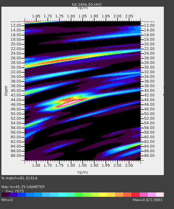
| Estimated Moho Depth: |
45.25 km |
| Estimated Crust Vp/Vs: |
1.79 |
| Assumed Crust Vp: |
6.476 km/s |
| Estimated Crust Vs: |
3.623 km/s |
| Estimated Crust Poisson's Ratio: |
0.27 |
|
| Radial Match: |
91.01916 % |
| Radial Bump: |
253 |
| Transverse Match: |
63.6222 % |
| Transverse Bump: |
358 |
| SOD ConfigId: |
30536071 |
| Insert Time: |
2023-04-05 16:19:26.268 +0000 |
| GWidth: |
2.5 |
| Max Bumps: |
400 |
| Tol: |
0.001 |
|

Signal To Noise
| Channel | StoN | STA | LTA |
| N4:X48A:00:HHZ:20230322T16:09:50.369978Z | 13.775366 | 6.179023E-6 | 4.48556E-7 |
| N4:X48A:00:HH1:20230322T16:09:50.369978Z | 6.8800178 | 2.7195495E-6 | 3.952823E-7 |
| N4:X48A:00:HH2:20230322T16:09:50.369978Z | 3.9477563 | 7.4789705E-7 | 1.8944864E-7 |
| Arrivals |
| Ps | 5.8 SECOND |
| PpPs | 19 SECOND |
| PsPs/PpSs | 24 SECOND |


