You are here: Home > Network List > O2 - Oklahoma Consolidated Temporary Seismic Networks Stations List
> Station PW18 Morrison, Oklahoma, USA > Earthquake Result Viewer
PW18 Morrison, Oklahoma, USA - Earthquake Result Viewer
| Earthquake location: |
Jujuy Province, Argentina |
| Earthquake latitude/longitude: |
-23.5/-66.5 |
| Earthquake time(UTC): |
2023/03/22 (081) 16:00:31 GMT |
| Earthquake Depth: |
210 km |
| Earthquake Magnitude: |
6.5 mww |
| Earthquake Catalog/Contributor: |
NEIC PDE/us |
|
| Network: |
O2 Oklahoma Consolidated Temporary Seismic Networks |
| Station: |
PW18 Morrison, Oklahoma, USA |
| Lat/Lon: |
36.28 N/97.04 W |
| Elevation: |
299 m |
|
| Distance: |
66.1 deg |
| Az: |
333.313 deg |
| Baz: |
149.313 deg |
| Ray Param: |
0.05723087 |
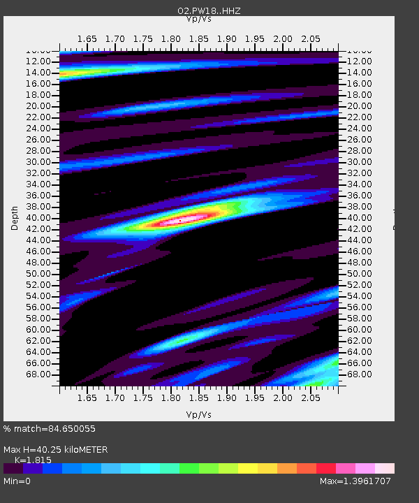
| Estimated Moho Depth: |
40.25 km |
| Estimated Crust Vp/Vs: |
1.82 |
| Assumed Crust Vp: |
6.483 km/s |
| Estimated Crust Vs: |
3.572 km/s |
| Estimated Crust Poisson's Ratio: |
0.28 |
|
| Radial Match: |
84.650055 % |
| Radial Bump: |
236 |
| Transverse Match: |
53.587673 % |
| Transverse Bump: |
387 |
| SOD ConfigId: |
30536071 |
| Insert Time: |
2023-04-05 16:23:08.506 +0000 |
| GWidth: |
2.5 |
| Max Bumps: |
400 |
| Tol: |
0.001 |
|

Signal To Noise
| Channel | StoN | STA | LTA |
| O2:PW18: :HHZ:20230322T16:10:24.590009Z | 13.920153 | 6.3496414E-6 | 4.5614738E-7 |
| O2:PW18: :HHN:20230322T16:10:24.590009Z | 4.097355 | 2.5238296E-6 | 6.159656E-7 |
| O2:PW18: :HHE:20230322T16:10:24.590009Z | 3.8689084 | 1.6187028E-6 | 4.1838746E-7 |
| Arrivals |
| Ps | 5.3 SECOND |
| PpPs | 17 SECOND |
| PsPs/PpSs | 22 SECOND |


