You are here: Home > Network List > US - United States National Seismic Network Stations List
> Station DGMT Dagmar, Montana, USA > Earthquake Result Viewer
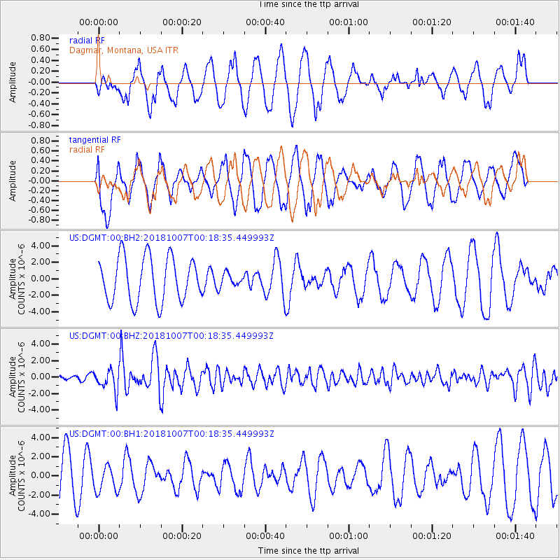
DGMT Dagmar, Montana, USA - Earthquake Result Viewer
*The percent match for this event was below the threshold and hence no stack was calculated.
| Earthquake location: |
Haiti Region |
| Earthquake latitude/longitude: |
20.0/-73.0 |
| Earthquake time(UTC): |
2018/10/07 (280) 00:11:49 GMT |
| Earthquake Depth: |
12 km |
| Earthquake Magnitude: |
5.9 Mww |
| Earthquake Catalog/Contributor: |
NEIC PDE/us |
|
| Network: |
US United States National Seismic Network |
| Station: |
DGMT Dagmar, Montana, USA |
| Lat/Lon: |
48.47 N/104.20 W |
| Elevation: |
0.0 m |
|
| Distance: |
37.9 deg |
| Az: |
325.815 deg |
| Baz: |
127.461 deg |
| Ray Param: |
$rayparam |
*The percent match for this event was below the threshold and hence was not used in the summary stack. |
|
| Radial Match: |
68.21086 % |
| Radial Bump: |
400 |
| Transverse Match: |
44.761868 % |
| Transverse Bump: |
400 |
| SOD ConfigId: |
3045211 |
| Insert Time: |
2018-10-21 00:30:21.958 +0000 |
| GWidth: |
2.5 |
| Max Bumps: |
400 |
| Tol: |
0.001 |
|
Signal To Noise
| Channel | StoN | STA | LTA |
| US:DGMT:00:BHZ:20181007T00:18:35.449993Z | 3.4251513 | 1.343552E-6 | 3.9226063E-7 |
| US:DGMT:00:BH1:20181007T00:18:35.449993Z | 0.412464 | 1.4050013E-6 | 3.4063612E-6 |
| US:DGMT:00:BH2:20181007T00:18:35.449993Z | 0.27171567 | 7.337983E-7 | 2.700611E-6 |
| Arrivals |
| Ps | |
| PpPs | |
| PsPs/PpSs | |


