You are here: Home > Network List > SC - New Mexico Tech Seismic Network Stations List
> Station GDL2 Guadalupe Mountains, New Mexico > Earthquake Result Viewer
GDL2 Guadalupe Mountains, New Mexico - Earthquake Result Viewer
| Earthquake location: |
Jujuy Province, Argentina |
| Earthquake latitude/longitude: |
-23.5/-66.5 |
| Earthquake time(UTC): |
2023/03/22 (081) 16:00:31 GMT |
| Earthquake Depth: |
210 km |
| Earthquake Magnitude: |
6.5 mww |
| Earthquake Catalog/Contributor: |
NEIC PDE/us |
|
| Network: |
SC New Mexico Tech Seismic Network |
| Station: |
GDL2 Guadalupe Mountains, New Mexico |
| Lat/Lon: |
32.20 N/104.36 W |
| Elevation: |
1211 m |
|
| Distance: |
66.1 deg |
| Az: |
325.329 deg |
| Baz: |
141.969 deg |
| Ray Param: |
0.057186 |
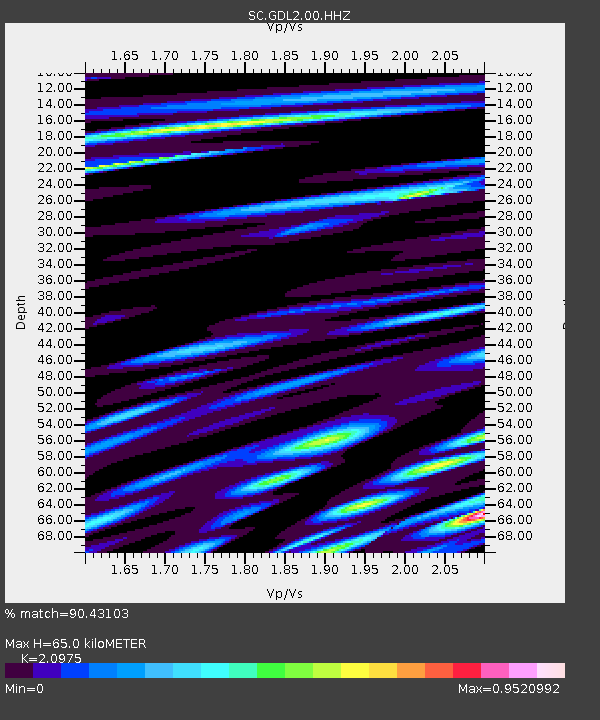
| Estimated Moho Depth: |
65.0 km |
| Estimated Crust Vp/Vs: |
2.10 |
| Assumed Crust Vp: |
6.232 km/s |
| Estimated Crust Vs: |
2.971 km/s |
| Estimated Crust Poisson's Ratio: |
0.35 |
|
| Radial Match: |
90.43103 % |
| Radial Bump: |
400 |
| Transverse Match: |
78.266075 % |
| Transverse Bump: |
400 |
| SOD ConfigId: |
30536071 |
| Insert Time: |
2023-04-05 16:27:47.746 +0000 |
| GWidth: |
2.5 |
| Max Bumps: |
400 |
| Tol: |
0.001 |
|

Signal To Noise
| Channel | StoN | STA | LTA |
| SC:GDL2:00:HHZ:20230322T16:10:25.035017Z | 70.461975 | 5.8752715E-7 | 8.338216E-9 |
| SC:GDL2:00:HHN:20230322T16:10:25.035017Z | 15.344447 | 1.0495096E-7 | 6.8396706E-9 |
| SC:GDL2:00:HHE:20230322T16:10:25.035017Z | 17.488548 | 1.0263886E-7 | 5.8689182E-9 |
| Arrivals |
| Ps | 12 SECOND |
| PpPs | 31 SECOND |
| PsPs/PpSs | 43 SECOND |


