You are here: Home > Network List > TA - USArray Transportable Network (new EarthScope stations) Stations List
> Station P23A Jefferson, CO, USA > Earthquake Result Viewer
P23A Jefferson, CO, USA - Earthquake Result Viewer
| Earthquake location: |
E. Russia-N.E. China Border Reg. |
| Earthquake latitude/longitude: |
42.6/130.7 |
| Earthquake time(UTC): |
2010/02/18 (049) 01:13:19 GMT |
| Earthquake Depth: |
578 km |
| Earthquake Magnitude: |
6.3 MB, 6.9 MW, 6.9 MW |
| Earthquake Catalog/Contributor: |
WHDF/NEIC |
|
| Network: |
TA USArray Transportable Network (new EarthScope stations) |
| Station: |
P23A Jefferson, CO, USA |
| Lat/Lon: |
39.37 N/105.84 W |
| Elevation: |
3006 m |
|
| Distance: |
83.7 deg |
| Az: |
40.59 deg |
| Baz: |
321.69 deg |
| Ray Param: |
0.044327762 |
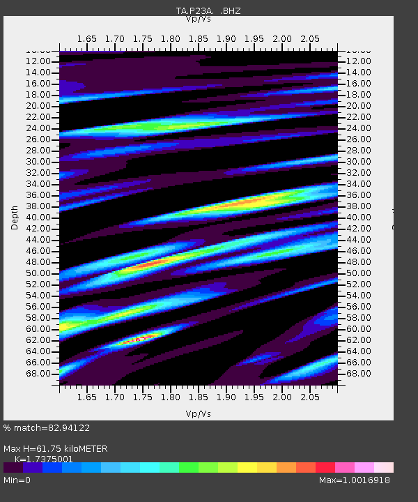
| Estimated Moho Depth: |
61.75 km |
| Estimated Crust Vp/Vs: |
1.74 |
| Assumed Crust Vp: |
6.159 km/s |
| Estimated Crust Vs: |
3.545 km/s |
| Estimated Crust Poisson's Ratio: |
0.25 |
|
| Radial Match: |
82.94122 % |
| Radial Bump: |
400 |
| Transverse Match: |
59.44898 % |
| Transverse Bump: |
400 |
| SOD ConfigId: |
306082 |
| Insert Time: |
2010-05-06 08:19:36.527 +0000 |
| GWidth: |
2.5 |
| Max Bumps: |
400 |
| Tol: |
0.001 |
|

Signal To Noise
| Channel | StoN | STA | LTA |
| TA:P23A: :BHZ:20100218T01:24:16.87499Z | 10.6012335 | 3.7524792E-6 | 3.539663E-7 |
| TA:P23A: :BHN:20100218T01:24:16.87499Z | 1.7179035 | 9.398428E-7 | 5.4708704E-7 |
| TA:P23A: :BHE:20100218T01:24:16.87499Z | 2.2079523 | 6.434995E-7 | 2.914463E-7 |
| Arrivals |
| Ps | 7.6 SECOND |
| PpPs | 27 SECOND |
| PsPs/PpSs | 34 SECOND |


