You are here: Home > Network List > US - United States National Seismic Network Stations List
> Station EGMT Eagleton, Montana, USA > Earthquake Result Viewer
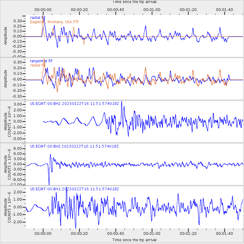
EGMT Eagleton, Montana, USA - Earthquake Result Viewer
*The percent match for this event was below the threshold and hence no stack was calculated.
| Earthquake location: |
Jujuy Province, Argentina |
| Earthquake latitude/longitude: |
-23.5/-66.5 |
| Earthquake time(UTC): |
2023/03/22 (081) 16:00:31 GMT |
| Earthquake Depth: |
210 km |
| Earthquake Magnitude: |
6.5 mww |
| Earthquake Catalog/Contributor: |
NEIC PDE/us |
|
| Network: |
US United States National Seismic Network |
| Station: |
EGMT Eagleton, Montana, USA |
| Lat/Lon: |
48.02 N/109.75 W |
| Elevation: |
1055 m |
|
| Distance: |
81.1 deg |
| Az: |
332.253 deg |
| Baz: |
140.448 deg |
| Ray Param: |
$rayparam |
*The percent match for this event was below the threshold and hence was not used in the summary stack. |
|
| Radial Match: |
66.52641 % |
| Radial Bump: |
373 |
| Transverse Match: |
63.787525 % |
| Transverse Bump: |
400 |
| SOD ConfigId: |
30536071 |
| Insert Time: |
2023-04-05 16:32:29.998 +0000 |
| GWidth: |
2.5 |
| Max Bumps: |
400 |
| Tol: |
0.001 |
|
Signal To Noise
| Channel | StoN | STA | LTA |
| US:EGMT:00:BHZ:20230322T16:11:51.574018Z | 7.752661 | 3.6968954E-6 | 4.76855E-7 |
| US:EGMT:00:BH1:20230322T16:11:51.574018Z | 0.92727506 | 5.3545085E-7 | 5.774455E-7 |
| US:EGMT:00:BH2:20230322T16:11:51.574018Z | 2.2545109 | 7.3914725E-7 | 3.278526E-7 |
| Arrivals |
| Ps | |
| PpPs | |
| PsPs/PpSs | |


