You are here: Home > Network List > TA - USArray Transportable Network (new EarthScope stations) Stations List
> Station F19A Roth Fram, Molt, MT, USA > Earthquake Result Viewer
F19A Roth Fram, Molt, MT, USA - Earthquake Result Viewer
| Earthquake location: |
E. Russia-N.E. China Border Reg. |
| Earthquake latitude/longitude: |
42.6/130.7 |
| Earthquake time(UTC): |
2010/02/18 (049) 01:13:19 GMT |
| Earthquake Depth: |
578 km |
| Earthquake Magnitude: |
6.3 MB, 6.9 MW, 6.9 MW |
| Earthquake Catalog/Contributor: |
WHDF/NEIC |
|
| Network: |
TA USArray Transportable Network (new EarthScope stations) |
| Station: |
F19A Roth Fram, Molt, MT, USA |
| Lat/Lon: |
45.85 N/108.94 W |
| Elevation: |
1243 m |
|
| Distance: |
77.2 deg |
| Az: |
38.203 deg |
| Baz: |
319.194 deg |
| Ray Param: |
0.04865236 |
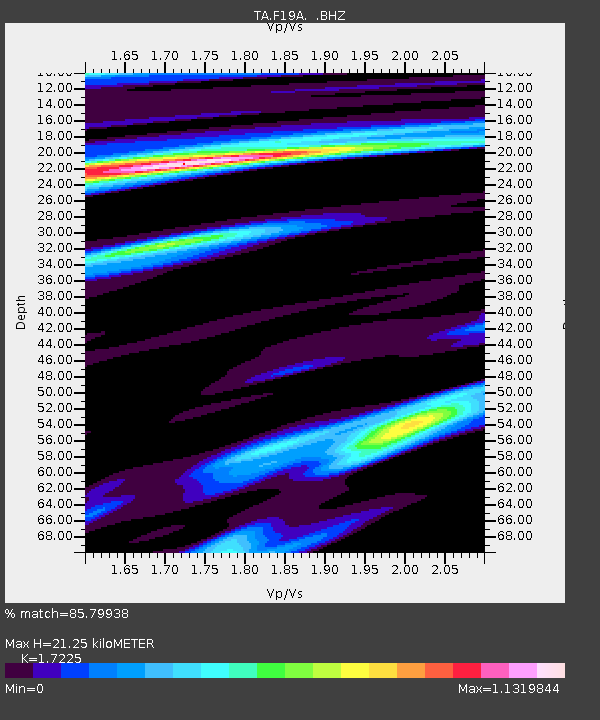
| Estimated Moho Depth: |
21.25 km |
| Estimated Crust Vp/Vs: |
1.72 |
| Assumed Crust Vp: |
6.242 km/s |
| Estimated Crust Vs: |
3.624 km/s |
| Estimated Crust Poisson's Ratio: |
0.25 |
|
| Radial Match: |
85.79938 % |
| Radial Bump: |
400 |
| Transverse Match: |
78.4276 % |
| Transverse Bump: |
362 |
| SOD ConfigId: |
306082 |
| Insert Time: |
2010-05-06 08:22:01.658 +0000 |
| GWidth: |
2.5 |
| Max Bumps: |
400 |
| Tol: |
0.001 |
|

Signal To Noise
| Channel | StoN | STA | LTA |
| TA:F19A: :BHZ:20100218T01:23:43.575002Z | 9.08972 | 4.2047554E-6 | 4.625836E-7 |
| TA:F19A: :BHN:20100218T01:23:43.575002Z | 3.3460786 | 1.1154586E-6 | 3.3336295E-7 |
| TA:F19A: :BHE:20100218T01:23:43.575002Z | 3.5159683 | 9.780653E-7 | 2.7817808E-7 |
| Arrivals |
| Ps | 2.5 SECOND |
| PpPs | 9.0 SECOND |
| PsPs/PpSs | 12 SECOND |


