You are here: Home > Network List > TA - USArray Transportable Network (new EarthScope stations) Stations List
> Station H19A Powell, WY, USA > Earthquake Result Viewer
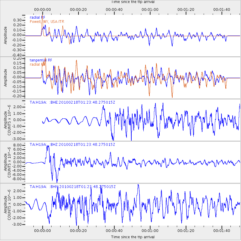
H19A Powell, WY, USA - Earthquake Result Viewer
*The percent match for this event was below the threshold and hence no stack was calculated.
| Earthquake location: |
E. Russia-N.E. China Border Reg. |
| Earthquake latitude/longitude: |
42.6/130.7 |
| Earthquake time(UTC): |
2010/02/18 (049) 01:13:19 GMT |
| Earthquake Depth: |
578 km |
| Earthquake Magnitude: |
6.3 MB, 6.9 MW, 6.9 MW |
| Earthquake Catalog/Contributor: |
WHDF/NEIC |
|
| Network: |
TA USArray Transportable Network (new EarthScope stations) |
| Station: |
H19A Powell, WY, USA |
| Lat/Lon: |
44.67 N/108.99 W |
| Elevation: |
1479 m |
|
| Distance: |
78.1 deg |
| Az: |
39.016 deg |
| Baz: |
319.338 deg |
| Ray Param: |
$rayparam |
*The percent match for this event was below the threshold and hence was not used in the summary stack. |
|
| Radial Match: |
76.09326 % |
| Radial Bump: |
400 |
| Transverse Match: |
70.56996 % |
| Transverse Bump: |
400 |
| SOD ConfigId: |
306082 |
| Insert Time: |
2010-05-06 08:22:51.270 +0000 |
| GWidth: |
2.5 |
| Max Bumps: |
400 |
| Tol: |
0.001 |
|
Signal To Noise
| Channel | StoN | STA | LTA |
| TA:H19A: :BHZ:20100218T01:23:48.275015Z | 11.534324 | 4.0052887E-6 | 3.4724957E-7 |
| TA:H19A: :BHN:20100218T01:23:48.275015Z | 2.7835705 | 1.1857188E-6 | 4.2597048E-7 |
| TA:H19A: :BHE:20100218T01:23:48.275015Z | 3.1554167 | 1.0354528E-6 | 3.281509E-7 |
| Arrivals |
| Ps | |
| PpPs | |
| PsPs/PpSs | |


