You are here: Home > Network List > UW - Pacific Northwest Regional Seismic Network Stations List
> Station MULN Lyman, WA, USA > Earthquake Result Viewer
MULN Lyman, WA, USA - Earthquake Result Viewer
| Earthquake location: |
Jujuy Province, Argentina |
| Earthquake latitude/longitude: |
-23.5/-66.5 |
| Earthquake time(UTC): |
2023/03/22 (081) 16:00:31 GMT |
| Earthquake Depth: |
210 km |
| Earthquake Magnitude: |
6.5 mww |
| Earthquake Catalog/Contributor: |
NEIC PDE/us |
|
| Network: |
UW Pacific Northwest Regional Seismic Network |
| Station: |
MULN Lyman, WA, USA |
| Lat/Lon: |
48.54 N/122.06 W |
| Elevation: |
102 m |
|
| Distance: |
87.2 deg |
| Az: |
326.717 deg |
| Baz: |
130.703 deg |
| Ray Param: |
0.043022376 |
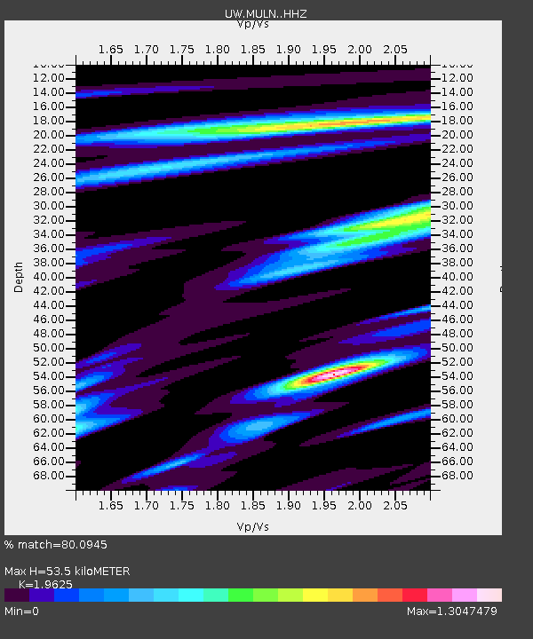
| Estimated Moho Depth: |
53.5 km |
| Estimated Crust Vp/Vs: |
1.96 |
| Assumed Crust Vp: |
6.566 km/s |
| Estimated Crust Vs: |
3.346 km/s |
| Estimated Crust Poisson's Ratio: |
0.32 |
|
| Radial Match: |
80.0945 % |
| Radial Bump: |
359 |
| Transverse Match: |
73.526924 % |
| Transverse Bump: |
400 |
| SOD ConfigId: |
30536071 |
| Insert Time: |
2023-04-05 16:36:10.709 +0000 |
| GWidth: |
2.5 |
| Max Bumps: |
400 |
| Tol: |
0.001 |
|

Signal To Noise
| Channel | StoN | STA | LTA |
| UW:MULN: :HHZ:20230322T16:12:22.230024Z | 9.698801 | 2.4292576E-6 | 2.5046987E-7 |
| UW:MULN: :HHN:20230322T16:12:22.230024Z | 3.9596276 | 9.304555E-7 | 2.349856E-7 |
| UW:MULN: :HHE:20230322T16:12:22.230024Z | 7.267576 | 1.001834E-6 | 1.3784981E-7 |
| Arrivals |
| Ps | 8.0 SECOND |
| PpPs | 24 SECOND |
| PsPs/PpSs | 32 SECOND |


