You are here: Home > Network List > TA - USArray Transportable Network (new EarthScope stations) Stations List
> Station H18A Shoshone NF, Cody, WY, USA > Earthquake Result Viewer
H18A Shoshone NF, Cody, WY, USA - Earthquake Result Viewer

| Earthquake location: |
E. Russia-N.E. China Border Reg. |
| Earthquake latitude/longitude: |
42.6/130.7 |
| Earthquake time(UTC): |
2010/02/18 (049) 01:13:19 GMT |
| Earthquake Depth: |
578 km |
| Earthquake Magnitude: |
6.3 MB, 6.9 MW, 6.9 MW |
| Earthquake Catalog/Contributor: |
WHDF/NEIC |
|
| Network: |
TA USArray Transportable Network (new EarthScope stations) |
| Station: |
H18A Shoshone NF, Cody, WY, USA |
| Lat/Lon: |
44.68 N/109.66 W |
| Elevation: |
2221 m |
|
| Distance: |
77.8 deg |
| Az: |
39.386 deg |
| Baz: |
318.94 deg |
| Ray Param: |
0.04828948 |
| Estimated Moho Depth: |
12.25 km |
| Estimated Crust Vp/Vs: |
1.71 |
| Assumed Crust Vp: |
6.242 km/s |
| Estimated Crust Vs: |
3.656 km/s |
| Estimated Crust Poisson's Ratio: |
0.24 |
|
| Radial Match: |
88.688156 % |
| Radial Bump: |
400 |
| Transverse Match: |
77.45749 % |
| Transverse Bump: |
400 |
| SOD ConfigId: |
306082 |
| Insert Time: |
2010-05-06 08:23:14.370 +0000 |
| GWidth: |
2.5 |
| Max Bumps: |
400 |
| Tol: |
0.001 |
|
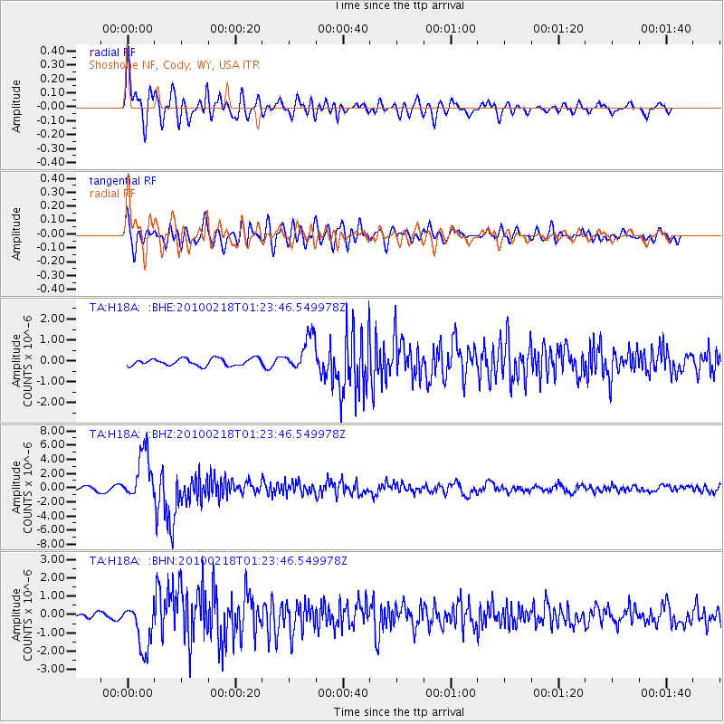
Signal To Noise
| Channel | StoN | STA | LTA |
| TA:H18A: :BHZ:20100218T01:23:46.549978Z | 11.91161 | 3.4660561E-6 | 2.9098132E-7 |
| TA:H18A: :BHN:20100218T01:23:46.549978Z | 8.837294 | 1.2769306E-6 | 1.444934E-7 |
| TA:H18A: :BHE:20100218T01:23:46.549978Z | 5.084728 | 8.4445594E-7 | 1.6607693E-7 |
| Arrivals |
| Ps | 1.4 SECOND |
| PpPs | 5.2 SECOND |
| PsPs/PpSs | 6.6 SECOND |


