You are here: Home > Network List > TX - Texas Seismological Network Stations List
> Station FW11 UT at Arlington > Earthquake Result Viewer
FW11 UT at Arlington - Earthquake Result Viewer
| Earthquake location: |
Pacific-Antarctic Ridge |
| Earthquake latitude/longitude: |
-54.4/-135.5 |
| Earthquake time(UTC): |
2018/10/07 (280) 01:06:51 GMT |
| Earthquake Depth: |
10 km |
| Earthquake Magnitude: |
5.6 Mww |
| Earthquake Catalog/Contributor: |
NEIC PDE/us |
|
| Network: |
TX Texas Seismological Network |
| Station: |
FW11 UT at Arlington |
| Lat/Lon: |
32.72 N/97.13 W |
| Elevation: |
198 m |
|
| Distance: |
92.9 deg |
| Az: |
31.619 deg |
| Baz: |
201.322 deg |
| Ray Param: |
0.041370843 |
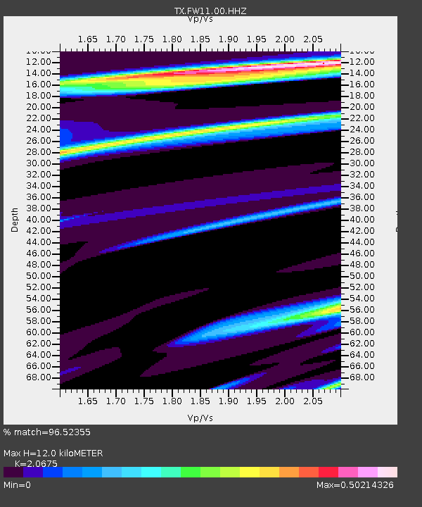
| Estimated Moho Depth: |
12.0 km |
| Estimated Crust Vp/Vs: |
2.07 |
| Assumed Crust Vp: |
6.38 km/s |
| Estimated Crust Vs: |
3.086 km/s |
| Estimated Crust Poisson's Ratio: |
0.35 |
|
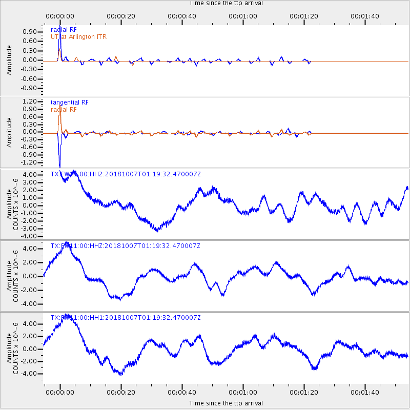
| Radial Match: |
96.52355 % |
| Radial Bump: |
228 |
| Transverse Match: |
93.91783 % |
| Transverse Bump: |
202 |
| SOD ConfigId: |
3045211 |
| Insert Time: |
2018-10-21 01:20:21.120 +0000 |
| GWidth: |
2.5 |
| Max Bumps: |
400 |
| Tol: |
0.001 |
|
Signal To Noise
| Channel | StoN | STA | LTA |
| TX:FW11:00:HHZ:20181007T01:19:32.470007Z | 2.7458725 | 6.2357667E-6 | 2.27096E-6 |
| TX:FW11:00:HH1:20181007T01:19:32.470007Z | 2.6048405 | 7.470296E-6 | 2.8678514E-6 |
| TX:FW11:00:HH2:20181007T01:19:32.470007Z | 2.5339417 | 4.1405547E-6 | 1.6340371E-6 |
| Arrivals |
| Ps | 2.0 SECOND |
| PpPs | 5.7 SECOND |
| PsPs/PpSs | 7.7 SECOND |


