You are here: Home > Network List > TA - USArray Transportable Network (new EarthScope stations) Stations List
> Station R23A Moffat, CO, USA > Earthquake Result Viewer
R23A Moffat, CO, USA - Earthquake Result Viewer
| Earthquake location: |
E. Russia-N.E. China Border Reg. |
| Earthquake latitude/longitude: |
42.6/130.7 |
| Earthquake time(UTC): |
2010/02/18 (049) 01:13:19 GMT |
| Earthquake Depth: |
578 km |
| Earthquake Magnitude: |
6.3 MB, 6.9 MW, 6.9 MW |
| Earthquake Catalog/Contributor: |
WHDF/NEIC |
|
| Network: |
TA USArray Transportable Network (new EarthScope stations) |
| Station: |
R23A Moffat, CO, USA |
| Lat/Lon: |
38.19 N/105.83 W |
| Elevation: |
2547 m |
|
| Distance: |
84.6 deg |
| Az: |
41.318 deg |
| Baz: |
321.772 deg |
| Ray Param: |
0.04368429 |
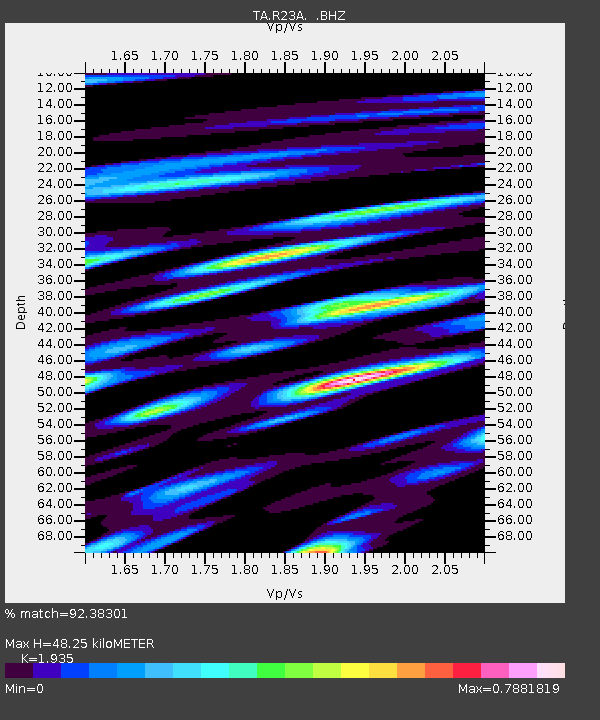
| Estimated Moho Depth: |
48.25 km |
| Estimated Crust Vp/Vs: |
1.93 |
| Assumed Crust Vp: |
6.159 km/s |
| Estimated Crust Vs: |
3.183 km/s |
| Estimated Crust Poisson's Ratio: |
0.32 |
|
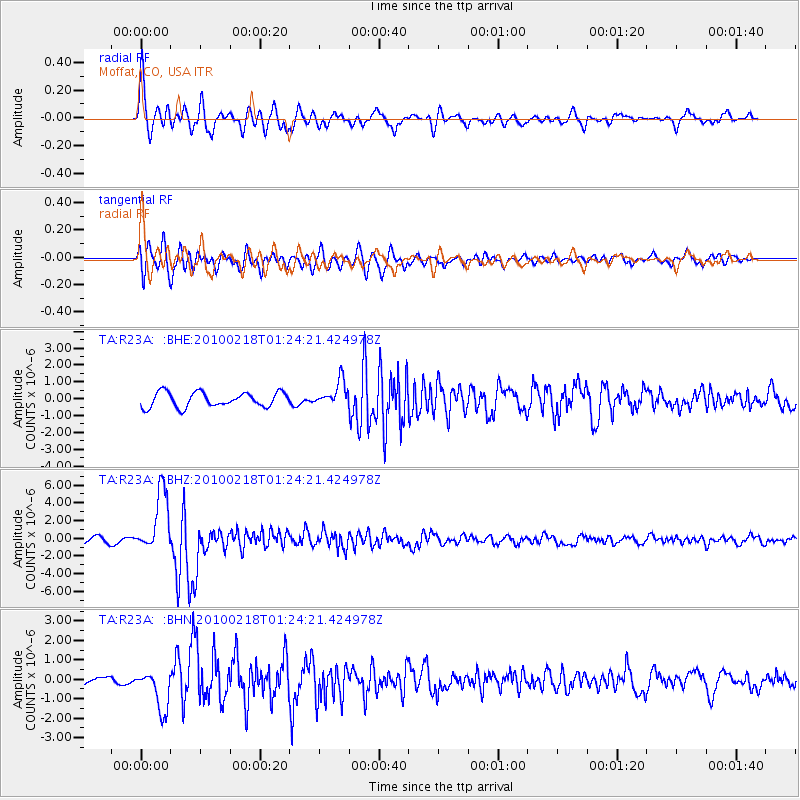
| Radial Match: |
92.38301 % |
| Radial Bump: |
400 |
| Transverse Match: |
74.43271 % |
| Transverse Bump: |
400 |
| SOD ConfigId: |
306082 |
| Insert Time: |
2010-05-06 08:26:55.692 +0000 |
| GWidth: |
2.5 |
| Max Bumps: |
400 |
| Tol: |
0.001 |
|
Signal To Noise
| Channel | StoN | STA | LTA |
| TA:R23A: :BHZ:20100218T01:24:21.424978Z | 9.507452 | 3.4992656E-6 | 3.6805505E-7 |
| TA:R23A: :BHN:20100218T01:24:21.424978Z | 4.847482 | 1.0445729E-6 | 2.154877E-7 |
| TA:R23A: :BHE:20100218T01:24:21.424978Z | 1.7213987 | 7.4550553E-7 | 4.3308125E-7 |
| Arrivals |
| Ps | 7.5 SECOND |
| PpPs | 23 SECOND |
| PsPs/PpSs | 30 SECOND |


