You are here: Home > Network List > TA - USArray Transportable Network (new EarthScope stations) Stations List
> Station E24A Baker, MT, USA > Earthquake Result Viewer
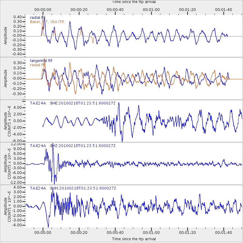
E24A Baker, MT, USA - Earthquake Result Viewer
*The percent match for this event was below the threshold and hence no stack was calculated.
| Earthquake location: |
E. Russia-N.E. China Border Reg. |
| Earthquake latitude/longitude: |
42.6/130.7 |
| Earthquake time(UTC): |
2010/02/18 (049) 01:13:19 GMT |
| Earthquake Depth: |
578 km |
| Earthquake Magnitude: |
6.3 MB, 6.9 MW, 6.9 MW |
| Earthquake Catalog/Contributor: |
WHDF/NEIC |
|
| Network: |
TA USArray Transportable Network (new EarthScope stations) |
| Station: |
E24A Baker, MT, USA |
| Lat/Lon: |
46.56 N/104.31 W |
| Elevation: |
912 m |
|
| Distance: |
78.7 deg |
| Az: |
35.202 deg |
| Baz: |
321.905 deg |
| Ray Param: |
$rayparam |
*The percent match for this event was below the threshold and hence was not used in the summary stack. |
|
| Radial Match: |
66.563614 % |
| Radial Bump: |
400 |
| Transverse Match: |
66.719826 % |
| Transverse Bump: |
386 |
| SOD ConfigId: |
306082 |
| Insert Time: |
2010-05-06 08:27:02.150 +0000 |
| GWidth: |
2.5 |
| Max Bumps: |
400 |
| Tol: |
0.001 |
|
Signal To Noise
| Channel | StoN | STA | LTA |
| TA:E24A: :BHZ:20100218T01:23:51.600027Z | 10.383854 | 4.12821E-6 | 3.9756048E-7 |
| TA:E24A: :BHN:20100218T01:23:51.600027Z | 3.0544102 | 1.9193976E-6 | 6.28402E-7 |
| TA:E24A: :BHE:20100218T01:23:51.600027Z | 0.7227107 | 6.504863E-7 | 9.0006455E-7 |
| Arrivals |
| Ps | |
| PpPs | |
| PsPs/PpSs | |


