You are here: Home > Network List > TA - USArray Transportable Network (new EarthScope stations) Stations List
> Station V29A Stinnett, TX, USA > Earthquake Result Viewer
V29A Stinnett, TX, USA - Earthquake Result Viewer

| Earthquake location: |
E. Russia-N.E. China Border Reg. |
| Earthquake latitude/longitude: |
42.6/130.7 |
| Earthquake time(UTC): |
2010/02/18 (049) 01:13:19 GMT |
| Earthquake Depth: |
578 km |
| Earthquake Magnitude: |
6.3 MB, 6.9 MW, 6.9 MW |
| Earthquake Catalog/Contributor: |
WHDF/NEIC |
|
| Network: |
TA USArray Transportable Network (new EarthScope stations) |
| Station: |
V29A Stinnett, TX, USA |
| Lat/Lon: |
35.87 N/101.52 W |
| Elevation: |
953 m |
|
| Distance: |
88.5 deg |
| Az: |
39.954 deg |
| Baz: |
324.273 deg |
| Ray Param: |
0.041652467 |
| Estimated Moho Depth: |
68.25 km |
| Estimated Crust Vp/Vs: |
1.68 |
| Assumed Crust Vp: |
6.426 km/s |
| Estimated Crust Vs: |
3.819 km/s |
| Estimated Crust Poisson's Ratio: |
0.23 |
|
| Radial Match: |
80.501366 % |
| Radial Bump: |
400 |
| Transverse Match: |
82.63857 % |
| Transverse Bump: |
400 |
| SOD ConfigId: |
306082 |
| Insert Time: |
2010-05-06 08:30:34.297 +0000 |
| GWidth: |
2.5 |
| Max Bumps: |
400 |
| Tol: |
0.001 |
|
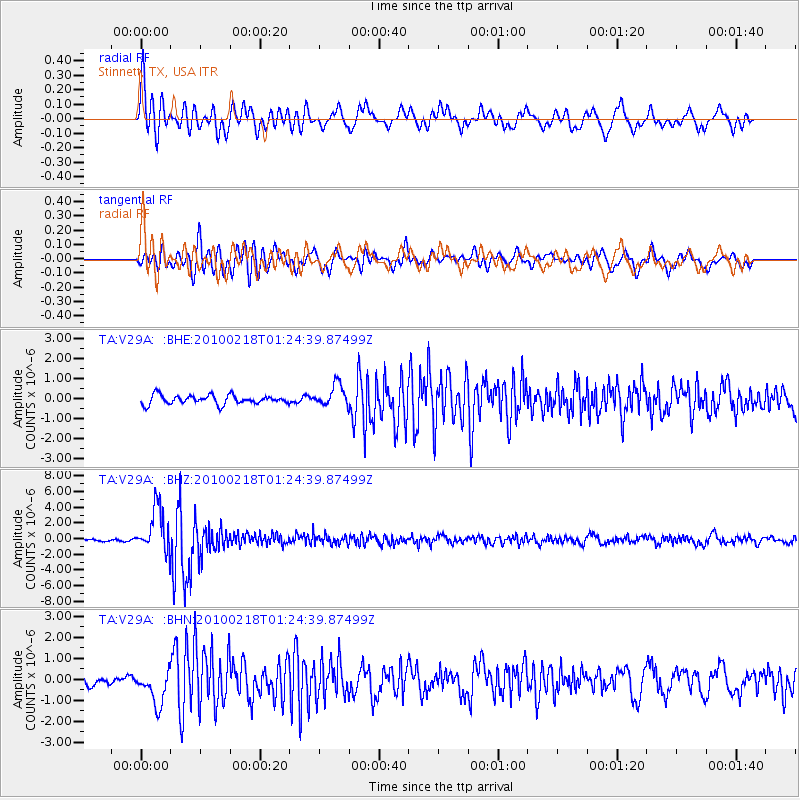
Signal To Noise
| Channel | StoN | STA | LTA |
| TA:V29A: :BHZ:20100218T01:24:39.87499Z | 8.050361 | 2.8339025E-6 | 3.520218E-7 |
| TA:V29A: :BHN:20100218T01:24:39.87499Z | 3.1194854 | 8.1853455E-7 | 2.6239408E-7 |
| TA:V29A: :BHE:20100218T01:24:39.87499Z | 2.4131372 | 5.437121E-7 | 2.2531337E-7 |
| Arrivals |
| Ps | 7.4 SECOND |
| PpPs | 28 SECOND |
| PsPs/PpSs | 35 SECOND |


