You are here: Home > Network List > UW - Pacific Northwest Regional Seismic Network Stations List
> Station UMAT Pilot Rock, OR, USA > Earthquake Result Viewer
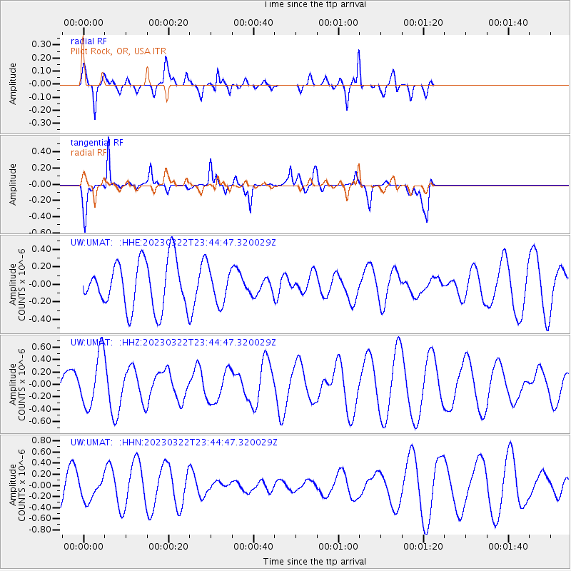
UMAT Pilot Rock, OR, USA - Earthquake Result Viewer
*The percent match for this event was below the threshold and hence no stack was calculated.
| Earthquake location: |
Philippine Islands Region |
| Earthquake latitude/longitude: |
19.3/121.2 |
| Earthquake time(UTC): |
2023/03/22 (081) 23:31:55 GMT |
| Earthquake Depth: |
30 km |
| Earthquake Magnitude: |
5.6 Mww |
| Earthquake Catalog/Contributor: |
NEIC PDE/us |
|
| Network: |
UW Pacific Northwest Regional Seismic Network |
| Station: |
UMAT Pilot Rock, OR, USA |
| Lat/Lon: |
45.29 N/118.96 W |
| Elevation: |
1318 m |
|
| Distance: |
95.7 deg |
| Az: |
37.963 deg |
| Baz: |
304.582 deg |
| Ray Param: |
$rayparam |
*The percent match for this event was below the threshold and hence was not used in the summary stack. |
|
| Radial Match: |
45.752773 % |
| Radial Bump: |
400 |
| Transverse Match: |
75.97086 % |
| Transverse Bump: |
295 |
| SOD ConfigId: |
30536071 |
| Insert Time: |
2023-04-05 23:45:48.647 +0000 |
| GWidth: |
2.5 |
| Max Bumps: |
400 |
| Tol: |
0.001 |
|
Signal To Noise
| Channel | StoN | STA | LTA |
| UW:UMAT: :HHZ:20230322T23:44:47.320029Z | 1.4789217 | 4.2951734E-7 | 2.9042604E-7 |
| UW:UMAT: :HHN:20230322T23:44:47.320029Z | 0.9947072 | 1.9075011E-7 | 1.9176508E-7 |
| UW:UMAT: :HHE:20230322T23:44:47.320029Z | 0.73476774 | 1.9722387E-7 | 2.684166E-7 |
| Arrivals |
| Ps | |
| PpPs | |
| PsPs/PpSs | |


