You are here: Home > Network List > TA - USArray Transportable Network (new EarthScope stations) Stations List
> Station 130A Snyder, TX, USA > Earthquake Result Viewer
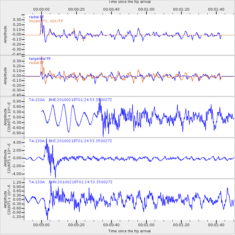
130A Snyder, TX, USA - Earthquake Result Viewer
*The percent match for this event was below the threshold and hence no stack was calculated.
| Earthquake location: |
E. Russia-N.E. China Border Reg. |
| Earthquake latitude/longitude: |
42.6/130.7 |
| Earthquake time(UTC): |
2010/02/18 (049) 01:13:19 GMT |
| Earthquake Depth: |
578 km |
| Earthquake Magnitude: |
6.3 MB, 6.9 MW, 6.9 MW |
| Earthquake Catalog/Contributor: |
WHDF/NEIC |
|
| Network: |
TA USArray Transportable Network (new EarthScope stations) |
| Station: |
130A Snyder, TX, USA |
| Lat/Lon: |
32.60 N/100.97 W |
| Elevation: |
676 m |
|
| Distance: |
91.4 deg |
| Az: |
41.481 deg |
| Baz: |
324.585 deg |
| Ray Param: |
$rayparam |
*The percent match for this event was below the threshold and hence was not used in the summary stack. |
|
| Radial Match: |
59.243908 % |
| Radial Bump: |
400 |
| Transverse Match: |
49.663128 % |
| Transverse Bump: |
400 |
| SOD ConfigId: |
306082 |
| Insert Time: |
2010-05-06 08:34:51.254 +0000 |
| GWidth: |
2.5 |
| Max Bumps: |
400 |
| Tol: |
0.001 |
|
Signal To Noise
| Channel | StoN | STA | LTA |
| TA:130A: :BHZ:20100218T01:24:53.350027Z | 9.64435 | 1.8509508E-6 | 1.9192075E-7 |
| TA:130A: :BHN:20100218T01:24:53.350027Z | 4.515873 | 5.421603E-7 | 1.200566E-7 |
| TA:130A: :BHE:20100218T01:24:53.350027Z | 0.9123515 | 3.733738E-7 | 4.092434E-7 |
| Arrivals |
| Ps | |
| PpPs | |
| PsPs/PpSs | |


