You are here: Home > Network List > TA - USArray Transportable Network (new EarthScope stations) Stations List
> Station S29A Ulysses, KS, USA > Earthquake Result Viewer
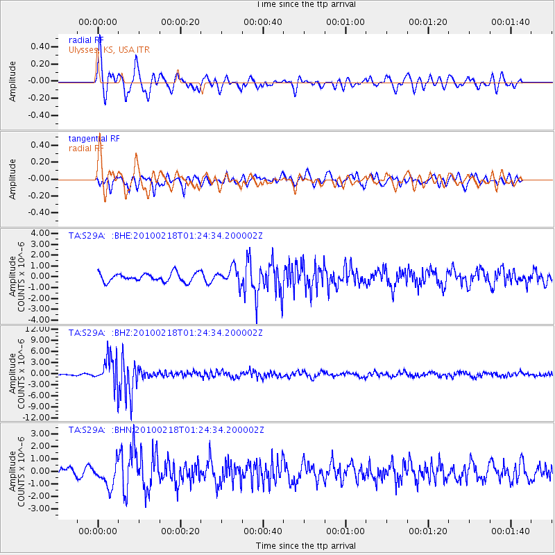
S29A Ulysses, KS, USA - Earthquake Result Viewer
*The percent match for this event was below the threshold and hence no stack was calculated.
| Earthquake location: |
E. Russia-N.E. China Border Reg. |
| Earthquake latitude/longitude: |
42.6/130.7 |
| Earthquake time(UTC): |
2010/02/18 (049) 01:13:19 GMT |
| Earthquake Depth: |
578 km |
| Earthquake Magnitude: |
6.3 MB, 6.9 MW, 6.9 MW |
| Earthquake Catalog/Contributor: |
WHDF/NEIC |
|
| Network: |
TA USArray Transportable Network (new EarthScope stations) |
| Station: |
S29A Ulysses, KS, USA |
| Lat/Lon: |
37.62 N/101.12 W |
| Elevation: |
931 m |
|
| Distance: |
87.3 deg |
| Az: |
38.674 deg |
| Baz: |
324.466 deg |
| Ray Param: |
$rayparam |
*The percent match for this event was below the threshold and hence was not used in the summary stack. |
|
| Radial Match: |
78.79031 % |
| Radial Bump: |
400 |
| Transverse Match: |
72.17527 % |
| Transverse Bump: |
400 |
| SOD ConfigId: |
306082 |
| Insert Time: |
2010-05-06 08:36:47.987 +0000 |
| GWidth: |
2.5 |
| Max Bumps: |
400 |
| Tol: |
0.001 |
|
Signal To Noise
| Channel | StoN | STA | LTA |
| TA:S29A: :BHZ:20100218T01:24:34.200002Z | 14.599048 | 3.9415736E-6 | 2.6998842E-7 |
| TA:S29A: :BHN:20100218T01:24:34.200002Z | 2.5170164 | 9.574972E-7 | 3.804096E-7 |
| TA:S29A: :BHE:20100218T01:24:34.200002Z | 1.9847755 | 7.7705516E-7 | 3.9150783E-7 |
| Arrivals |
| Ps | |
| PpPs | |
| PsPs/PpSs | |


