You are here: Home > Network List > TA - USArray Transportable Network (new EarthScope stations) Stations List
> Station R29A Marienthal, KS, USA > Earthquake Result Viewer
R29A Marienthal, KS, USA - Earthquake Result Viewer
| Earthquake location: |
E. Russia-N.E. China Border Reg. |
| Earthquake latitude/longitude: |
42.6/130.7 |
| Earthquake time(UTC): |
2010/02/18 (049) 01:13:19 GMT |
| Earthquake Depth: |
578 km |
| Earthquake Magnitude: |
6.3 MB, 6.9 MW, 6.9 MW |
| Earthquake Catalog/Contributor: |
WHDF/NEIC |
|
| Network: |
TA USArray Transportable Network (new EarthScope stations) |
| Station: |
R29A Marienthal, KS, USA |
| Lat/Lon: |
38.42 N/101.14 W |
| Elevation: |
957 m |
|
| Distance: |
86.6 deg |
| Az: |
38.22 deg |
| Baz: |
324.43 deg |
| Ray Param: |
0.04225811 |
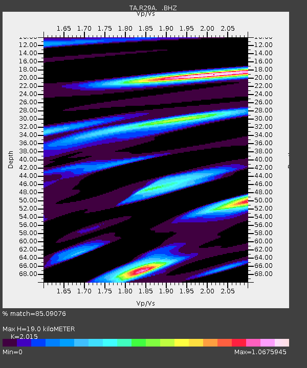
| Estimated Moho Depth: |
19.0 km |
| Estimated Crust Vp/Vs: |
2.02 |
| Assumed Crust Vp: |
6.483 km/s |
| Estimated Crust Vs: |
3.217 km/s |
| Estimated Crust Poisson's Ratio: |
0.34 |
|
| Radial Match: |
85.09076 % |
| Radial Bump: |
368 |
| Transverse Match: |
55.927753 % |
| Transverse Bump: |
380 |
| SOD ConfigId: |
306082 |
| Insert Time: |
2010-05-06 08:37:46.007 +0000 |
| GWidth: |
2.5 |
| Max Bumps: |
400 |
| Tol: |
0.001 |
|
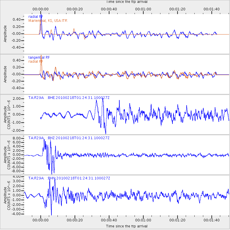
Signal To Noise
| Channel | StoN | STA | LTA |
| TA:R29A: :BHZ:20100218T01:24:31.100027Z | 14.966632 | 3.5908226E-6 | 2.399219E-7 |
| TA:R29A: :BHN:20100218T01:24:31.100027Z | 2.7366848 | 1.0490807E-6 | 3.8333997E-7 |
| TA:R29A: :BHE:20100218T01:24:31.100027Z | 3.9323738 | 7.8826713E-7 | 2.004558E-7 |
| Arrivals |
| Ps | 3.0 SECOND |
| PpPs | 8.7 SECOND |
| PsPs/PpSs | 12 SECOND |


