You are here: Home > Network List > TA - USArray Transportable Network (new EarthScope stations) Stations List
> Station Q28A Sharon Springs, KS, USA > Earthquake Result Viewer
Q28A Sharon Springs, KS, USA - Earthquake Result Viewer

| Earthquake location: |
E. Russia-N.E. China Border Reg. |
| Earthquake latitude/longitude: |
42.6/130.7 |
| Earthquake time(UTC): |
2010/02/18 (049) 01:13:19 GMT |
| Earthquake Depth: |
578 km |
| Earthquake Magnitude: |
6.3 MB, 6.9 MW, 6.9 MW |
| Earthquake Catalog/Contributor: |
WHDF/NEIC |
|
| Network: |
TA USArray Transportable Network (new EarthScope stations) |
| Station: |
Q28A Sharon Springs, KS, USA |
| Lat/Lon: |
39.06 N/101.83 W |
| Elevation: |
1133 m |
|
| Distance: |
85.8 deg |
| Az: |
38.287 deg |
| Baz: |
324.002 deg |
| Ray Param: |
0.042850792 |
| Estimated Moho Depth: |
36.0 km |
| Estimated Crust Vp/Vs: |
1.73 |
| Assumed Crust Vp: |
6.483 km/s |
| Estimated Crust Vs: |
3.758 km/s |
| Estimated Crust Poisson's Ratio: |
0.25 |
|
| Radial Match: |
85.552345 % |
| Radial Bump: |
400 |
| Transverse Match: |
65.64945 % |
| Transverse Bump: |
400 |
| SOD ConfigId: |
306082 |
| Insert Time: |
2010-05-06 08:38:01.142 +0000 |
| GWidth: |
2.5 |
| Max Bumps: |
400 |
| Tol: |
0.001 |
|
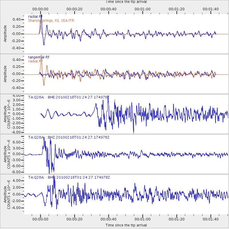
Signal To Noise
| Channel | StoN | STA | LTA |
| TA:Q28A: :BHZ:20100218T01:24:27.174978Z | 16.419283 | 3.72169E-6 | 2.2666582E-7 |
| TA:Q28A: :BHN:20100218T01:24:27.174978Z | 3.605399 | 1.4976067E-6 | 4.1537893E-7 |
| TA:Q28A: :BHE:20100218T01:24:27.174978Z | 3.0556183 | 1.1893892E-6 | 3.8924665E-7 |
| Arrivals |
| Ps | 4.1 SECOND |
| PpPs | 15 SECOND |
| PsPs/PpSs | 19 SECOND |


