You are here: Home > Network List > TA - USArray Transportable Network (new EarthScope stations) Stations List
> Station L29A Maesberg Ranch, Thedford, NE, USA > Earthquake Result Viewer
L29A Maesberg Ranch, Thedford, NE, USA - Earthquake Result Viewer
| Earthquake location: |
E. Russia-N.E. China Border Reg. |
| Earthquake latitude/longitude: |
42.6/130.7 |
| Earthquake time(UTC): |
2010/02/18 (049) 01:13:19 GMT |
| Earthquake Depth: |
578 km |
| Earthquake Magnitude: |
6.3 MB, 6.9 MW, 6.9 MW |
| Earthquake Catalog/Contributor: |
WHDF/NEIC |
|
| Network: |
TA USArray Transportable Network (new EarthScope stations) |
| Station: |
L29A Maesberg Ranch, Thedford, NE, USA |
| Lat/Lon: |
42.06 N/100.48 W |
| Elevation: |
901 m |
|
| Distance: |
84.0 deg |
| Az: |
35.691 deg |
| Baz: |
324.647 deg |
| Ray Param: |
0.04412861 |
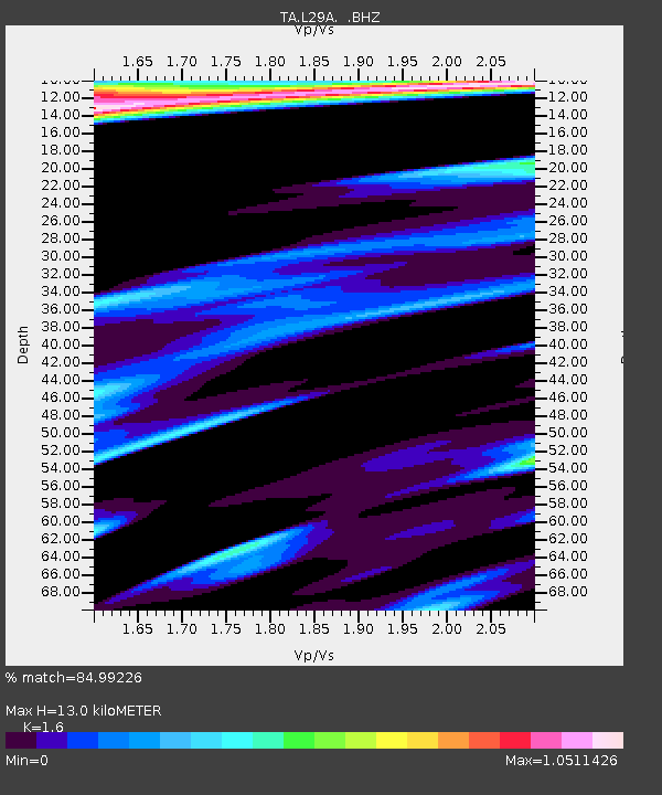
| Estimated Moho Depth: |
13.0 km |
| Estimated Crust Vp/Vs: |
1.60 |
| Assumed Crust Vp: |
6.483 km/s |
| Estimated Crust Vs: |
4.052 km/s |
| Estimated Crust Poisson's Ratio: |
0.18 |
|
| Radial Match: |
84.99226 % |
| Radial Bump: |
366 |
| Transverse Match: |
65.77851 % |
| Transverse Bump: |
351 |
| SOD ConfigId: |
306082 |
| Insert Time: |
2010-05-06 08:40:07.034 +0000 |
| GWidth: |
2.5 |
| Max Bumps: |
400 |
| Tol: |
0.001 |
|
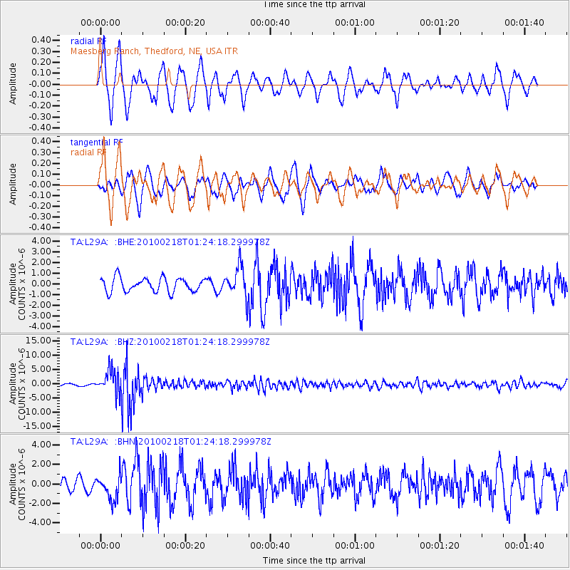
Signal To Noise
| Channel | StoN | STA | LTA |
| TA:L29A: :BHZ:20100218T01:24:18.299978Z | 12.001951 | 4.22883E-6 | 3.5234524E-7 |
| TA:L29A: :BHN:20100218T01:24:18.299978Z | 1.6238458 | 1.2831456E-6 | 7.901893E-7 |
| TA:L29A: :BHE:20100218T01:24:18.299978Z | 2.2228067 | 1.4577664E-6 | 6.5582236E-7 |
| Arrivals |
| Ps | 1.2 SECOND |
| PpPs | 5.1 SECOND |
| PsPs/PpSs | 6.3 SECOND |


