You are here: Home > Network List > TA - USArray Transportable Network (new EarthScope stations) Stations List
> Station I28A Midland, SD, USA > Earthquake Result Viewer
I28A Midland, SD, USA - Earthquake Result Viewer
| Earthquake location: |
E. Russia-N.E. China Border Reg. |
| Earthquake latitude/longitude: |
42.6/130.7 |
| Earthquake time(UTC): |
2010/02/18 (049) 01:13:19 GMT |
| Earthquake Depth: |
578 km |
| Earthquake Magnitude: |
6.3 MB, 6.9 MW, 6.9 MW |
| Earthquake Catalog/Contributor: |
WHDF/NEIC |
|
| Network: |
TA USArray Transportable Network (new EarthScope stations) |
| Station: |
I28A Midland, SD, USA |
| Lat/Lon: |
44.00 N/101.17 W |
| Elevation: |
655 m |
|
| Distance: |
82.1 deg |
| Az: |
34.97 deg |
| Baz: |
324.089 deg |
| Ray Param: |
0.045405377 |
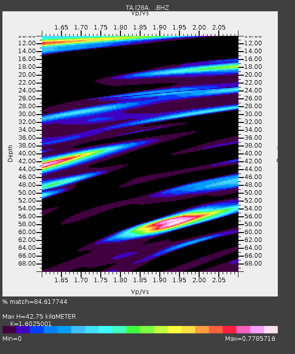
| Estimated Moho Depth: |
42.75 km |
| Estimated Crust Vp/Vs: |
1.60 |
| Assumed Crust Vp: |
6.483 km/s |
| Estimated Crust Vs: |
4.045 km/s |
| Estimated Crust Poisson's Ratio: |
0.18 |
|
| Radial Match: |
84.617744 % |
| Radial Bump: |
400 |
| Transverse Match: |
69.24089 % |
| Transverse Bump: |
400 |
| SOD ConfigId: |
306082 |
| Insert Time: |
2010-05-06 08:41:08.932 +0000 |
| GWidth: |
2.5 |
| Max Bumps: |
400 |
| Tol: |
0.001 |
|
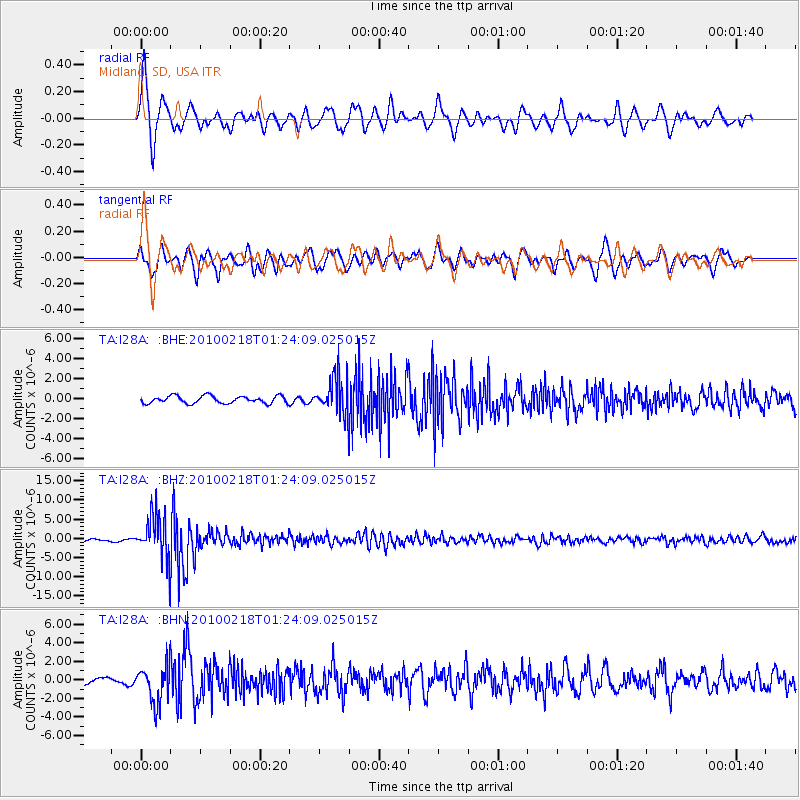
Signal To Noise
| Channel | StoN | STA | LTA |
| TA:I28A: :BHZ:20100218T01:24:09.025015Z | 26.818943 | 5.554922E-6 | 2.0712682E-7 |
| TA:I28A: :BHN:20100218T01:24:09.025015Z | 5.3429585 | 2.0109337E-6 | 3.7637085E-7 |
| TA:I28A: :BHE:20100218T01:24:09.025015Z | 4.9314785 | 1.834044E-6 | 3.7190551E-7 |
| Arrivals |
| Ps | 4.1 SECOND |
| PpPs | 17 SECOND |
| PsPs/PpSs | 21 SECOND |


