You are here: Home > Network List > TA - USArray Transportable Network (new EarthScope stations) Stations List
> Station I27A Quinn, SD, USA > Earthquake Result Viewer
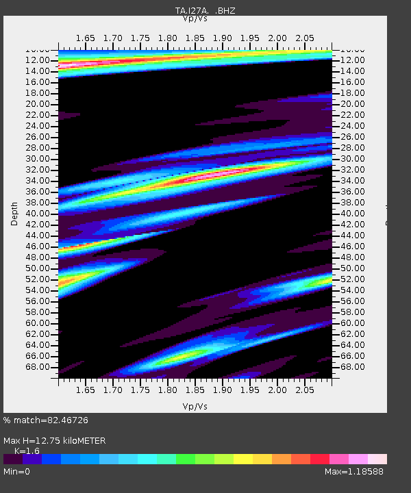
I27A Quinn, SD, USA - Earthquake Result Viewer
| Earthquake location: |
E. Russia-N.E. China Border Reg. |
| Earthquake latitude/longitude: |
42.6/130.7 |
| Earthquake time(UTC): |
2010/02/18 (049) 01:13:19 GMT |
| Earthquake Depth: |
578 km |
| Earthquake Magnitude: |
6.3 MB, 6.9 MW, 6.9 MW |
| Earthquake Catalog/Contributor: |
WHDF/NEIC |
|
| Network: |
TA USArray Transportable Network (new EarthScope stations) |
| Station: |
I27A Quinn, SD, USA |
| Lat/Lon: |
44.07 N/102.05 W |
| Elevation: |
867 m |
|
| Distance: |
81.7 deg |
| Az: |
35.448 deg |
| Baz: |
323.545 deg |
| Ray Param: |
0.045696463 |
| Estimated Moho Depth: |
12.75 km |
| Estimated Crust Vp/Vs: |
1.60 |
| Assumed Crust Vp: |
6.242 km/s |
| Estimated Crust Vs: |
3.901 km/s |
| Estimated Crust Poisson's Ratio: |
0.18 |
|
| Radial Match: |
82.46726 % |
| Radial Bump: |
283 |
| Transverse Match: |
79.23057 % |
| Transverse Bump: |
347 |
| SOD ConfigId: |
306082 |
| Insert Time: |
2010-05-06 08:41:09.532 +0000 |
| GWidth: |
2.5 |
| Max Bumps: |
400 |
| Tol: |
0.001 |
|

Signal To Noise
| Channel | StoN | STA | LTA |
| TA:I27A: :BHZ:20100218T01:24:06.825002Z | 15.494469 | 5.466299E-6 | 3.5279035E-7 |
| TA:I27A: :BHN:20100218T01:24:06.825002Z | 2.9155276 | 2.1451137E-6 | 7.357549E-7 |
| TA:I27A: :BHE:20100218T01:24:06.825002Z | 2.3090696 | 1.518299E-6 | 6.575371E-7 |
| Arrivals |
| Ps | 1.3 SECOND |
| PpPs | 5.2 SECOND |
| PsPs/PpSs | 6.4 SECOND |


