You are here: Home > Network List > G - GEOSCOPE Stations List
> Station INU Inuyama, Japan > Earthquake Result Viewer
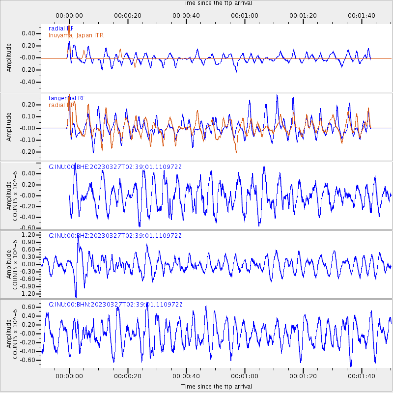
INU Inuyama, Japan - Earthquake Result Viewer
*The percent match for this event was below the threshold and hence no stack was calculated.
| Earthquake location: |
Fiji Islands Region |
| Earthquake latitude/longitude: |
-17.8/-178.2 |
| Earthquake time(UTC): |
2023/03/27 (086) 02:29:21 GMT |
| Earthquake Depth: |
467 km |
| Earthquake Magnitude: |
5.5 mww |
| Earthquake Catalog/Contributor: |
NEIC PDE/us |
|
| Network: |
G GEOSCOPE |
| Station: |
INU Inuyama, Japan |
| Lat/Lon: |
35.35 N/137.03 E |
| Elevation: |
132 m |
|
| Distance: |
67.8 deg |
| Az: |
321.566 deg |
| Baz: |
133.586 deg |
| Ray Param: |
$rayparam |
*The percent match for this event was below the threshold and hence was not used in the summary stack. |
|
| Radial Match: |
50.698208 % |
| Radial Bump: |
400 |
| Transverse Match: |
60.508762 % |
| Transverse Bump: |
400 |
| SOD ConfigId: |
30536071 |
| Insert Time: |
2023-04-10 02:39:07.442 +0000 |
| GWidth: |
2.5 |
| Max Bumps: |
400 |
| Tol: |
0.001 |
|
Signal To Noise
| Channel | StoN | STA | LTA |
| G:INU:00:BHZ:20230327T02:39:01.110972Z | 2.5610468 | 5.9798845E-7 | 2.3349375E-7 |
| G:INU:00:BHN:20230327T02:39:01.110972Z | 0.8363983 | 2.748713E-7 | 3.2863684E-7 |
| G:INU:00:BHE:20230327T02:39:01.110972Z | 1.1396389 | 2.6140472E-7 | 2.2937503E-7 |
| Arrivals |
| Ps | |
| PpPs | |
| PsPs/PpSs | |


