You are here: Home > Network List > IU - Global Seismograph Network (GSN - IRIS/USGS) Stations List
> Station PMG Port Moresby, New Guinea > Earthquake Result Viewer
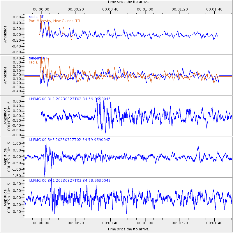
PMG Port Moresby, New Guinea - Earthquake Result Viewer
*The percent match for this event was below the threshold and hence no stack was calculated.
| Earthquake location: |
Fiji Islands Region |
| Earthquake latitude/longitude: |
-17.8/-178.2 |
| Earthquake time(UTC): |
2023/03/27 (086) 02:29:21 GMT |
| Earthquake Depth: |
467 km |
| Earthquake Magnitude: |
5.5 mww |
| Earthquake Catalog/Contributor: |
NEIC PDE/us |
|
| Network: |
IU Global Seismograph Network (GSN - IRIS/USGS) |
| Station: |
PMG Port Moresby, New Guinea |
| Lat/Lon: |
9.40 S/147.16 E |
| Elevation: |
90 m |
|
| Distance: |
34.6 deg |
| Az: |
279.367 deg |
| Baz: |
107.732 deg |
| Ray Param: |
$rayparam |
*The percent match for this event was below the threshold and hence was not used in the summary stack. |
|
| Radial Match: |
72.48894 % |
| Radial Bump: |
400 |
| Transverse Match: |
60.690742 % |
| Transverse Bump: |
400 |
| SOD ConfigId: |
30536071 |
| Insert Time: |
2023-04-10 02:40:36.472 +0000 |
| GWidth: |
2.5 |
| Max Bumps: |
400 |
| Tol: |
0.001 |
|
Signal To Noise
| Channel | StoN | STA | LTA |
| IU:PMG:00:BHZ:20230327T02:34:59.969004Z | 5.4865227 | 5.3475037E-7 | 9.746618E-8 |
| IU:PMG:00:BH1:20230327T02:34:59.969004Z | 0.8743856 | 9.867174E-8 | 1.1284695E-7 |
| IU:PMG:00:BH2:20230327T02:34:59.969004Z | 3.5631711 | 3.570333E-7 | 1.0020099E-7 |
| Arrivals |
| Ps | |
| PpPs | |
| PsPs/PpSs | |


