You are here: Home > Network List > US - United States National Seismic Network Stations List
> Station NEW Newport, Washington, USA > Earthquake Result Viewer
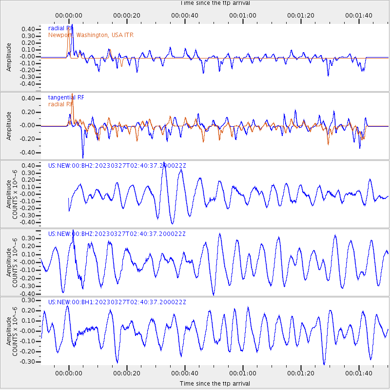
NEW Newport, Washington, USA - Earthquake Result Viewer
*The percent match for this event was below the threshold and hence no stack was calculated.
| Earthquake location: |
Fiji Islands Region |
| Earthquake latitude/longitude: |
-17.8/-178.2 |
| Earthquake time(UTC): |
2023/03/27 (086) 02:29:21 GMT |
| Earthquake Depth: |
467 km |
| Earthquake Magnitude: |
5.5 mww |
| Earthquake Catalog/Contributor: |
NEIC PDE/us |
|
| Network: |
US United States National Seismic Network |
| Station: |
NEW Newport, Washington, USA |
| Lat/Lon: |
48.26 N/117.12 W |
| Elevation: |
760 m |
|
| Distance: |
85.3 deg |
| Az: |
35.936 deg |
| Baz: |
236.787 deg |
| Ray Param: |
$rayparam |
*The percent match for this event was below the threshold and hence was not used in the summary stack. |
|
| Radial Match: |
59.21618 % |
| Radial Bump: |
400 |
| Transverse Match: |
73.54021 % |
| Transverse Bump: |
400 |
| SOD ConfigId: |
30536071 |
| Insert Time: |
2023-04-10 02:47:41.375 +0000 |
| GWidth: |
2.5 |
| Max Bumps: |
400 |
| Tol: |
0.001 |
|
Signal To Noise
| Channel | StoN | STA | LTA |
| US:NEW:00:BHZ:20230327T02:40:37.200022Z | 1.9121637 | 2.0041648E-7 | 1.0481136E-7 |
| US:NEW:00:BH1:20230327T02:40:37.200022Z | 1.051945 | 1.2567702E-7 | 1.194711E-7 |
| US:NEW:00:BH2:20230327T02:40:37.200022Z | 2.740492 | 2.5583725E-7 | 9.3354494E-8 |
| Arrivals |
| Ps | |
| PpPs | |
| PsPs/PpSs | |


