You are here: Home > Network List > TA - USArray Transportable Network (new EarthScope stations) Stations List
> Station H29A Onida, SD, USA > Earthquake Result Viewer
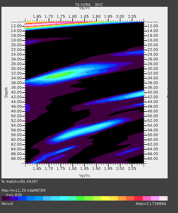
H29A Onida, SD, USA - Earthquake Result Viewer
| Earthquake location: |
E. Russia-N.E. China Border Reg. |
| Earthquake latitude/longitude: |
42.6/130.7 |
| Earthquake time(UTC): |
2010/02/18 (049) 01:13:19 GMT |
| Earthquake Depth: |
578 km |
| Earthquake Magnitude: |
6.3 MB, 6.9 MW, 6.9 MW |
| Earthquake Catalog/Contributor: |
WHDF/NEIC |
|
| Network: |
TA USArray Transportable Network (new EarthScope stations) |
| Station: |
H29A Onida, SD, USA |
| Lat/Lon: |
44.63 N/100.21 W |
| Elevation: |
548 m |
|
| Distance: |
82.0 deg |
| Az: |
34.038 deg |
| Baz: |
324.626 deg |
| Ray Param: |
0.045480072 |
| Estimated Moho Depth: |
11.25 km |
| Estimated Crust Vp/Vs: |
1.63 |
| Assumed Crust Vp: |
6.53 km/s |
| Estimated Crust Vs: |
3.994 km/s |
| Estimated Crust Poisson's Ratio: |
0.20 |
|
| Radial Match: |
90.44297 % |
| Radial Bump: |
355 |
| Transverse Match: |
85.54536 % |
| Transverse Bump: |
400 |
| SOD ConfigId: |
306082 |
| Insert Time: |
2010-05-06 08:45:51.360 +0000 |
| GWidth: |
2.5 |
| Max Bumps: |
400 |
| Tol: |
0.001 |
|

Signal To Noise
| Channel | StoN | STA | LTA |
| TA:H29A: :BHZ:20100218T01:24:08.475027Z | 29.631214 | 6.320436E-6 | 2.1330332E-7 |
| TA:H29A: :BHN:20100218T01:24:08.475027Z | 3.3384395 | 1.9724487E-6 | 5.908296E-7 |
| TA:H29A: :BHE:20100218T01:24:08.475027Z | 3.7889144 | 1.4616102E-6 | 3.857596E-7 |
| Arrivals |
| Ps | 1.1 SECOND |
| PpPs | 4.4 SECOND |
| PsPs/PpSs | 5.5 SECOND |


