You are here: Home > Network List > TA - USArray Transportable Network (new EarthScope stations) Stations List
> Station J30A Dallas, SD, USA > Earthquake Result Viewer
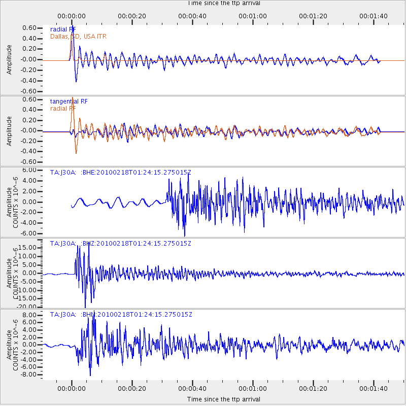
J30A Dallas, SD, USA - Earthquake Result Viewer

| Earthquake location: |
E. Russia-N.E. China Border Reg. |
| Earthquake latitude/longitude: |
42.6/130.7 |
| Earthquake time(UTC): |
2010/02/18 (049) 01:13:19 GMT |
| Earthquake Depth: |
578 km |
| Earthquake Magnitude: |
6.3 MB, 6.9 MW, 6.9 MW |
| Earthquake Catalog/Contributor: |
WHDF/NEIC |
|
| Network: |
TA USArray Transportable Network (new EarthScope stations) |
| Station: |
J30A Dallas, SD, USA |
| Lat/Lon: |
43.32 N/99.49 W |
| Elevation: |
608 m |
|
| Distance: |
83.3 deg |
| Az: |
34.363 deg |
| Baz: |
325.166 deg |
| Ray Param: |
0.044544853 |
| Estimated Moho Depth: |
28.5 km |
| Estimated Crust Vp/Vs: |
1.62 |
| Assumed Crust Vp: |
6.53 km/s |
| Estimated Crust Vs: |
4.031 km/s |
| Estimated Crust Poisson's Ratio: |
0.19 |
|
| Radial Match: |
92.1002 % |
| Radial Bump: |
400 |
| Transverse Match: |
79.47504 % |
| Transverse Bump: |
400 |
| SOD ConfigId: |
306082 |
| Insert Time: |
2010-05-06 08:46:07.084 +0000 |
| GWidth: |
2.5 |
| Max Bumps: |
400 |
| Tol: |
0.001 |
|
Signal To Noise
| Channel | StoN | STA | LTA |
| TA:J30A: :BHZ:20100218T01:24:15.275015Z | 21.54285 | 7.656052E-6 | 3.5538713E-7 |
| TA:J30A: :BHN:20100218T01:24:15.275015Z | 6.3760076 | 2.0686011E-6 | 3.2443515E-7 |
| TA:J30A: :BHE:20100218T01:24:15.275015Z | 2.888401 | 1.5159682E-6 | 5.248468E-7 |
| Arrivals |
| Ps | 2.8 SECOND |
| PpPs | 11 SECOND |
| PsPs/PpSs | 14 SECOND |


