You are here: Home > Network List > TA - USArray Transportable Network (new EarthScope stations) Stations List
> Station J29A Okreek, SD, USA > Earthquake Result Viewer
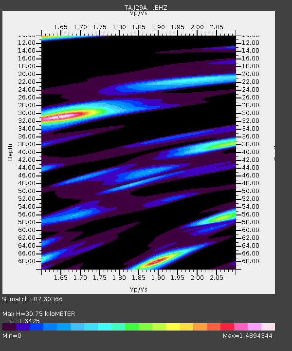
J29A Okreek, SD, USA - Earthquake Result Viewer
| Earthquake location: |
E. Russia-N.E. China Border Reg. |
| Earthquake latitude/longitude: |
42.6/130.7 |
| Earthquake time(UTC): |
2010/02/18 (049) 01:13:19 GMT |
| Earthquake Depth: |
578 km |
| Earthquake Magnitude: |
6.3 MB, 6.9 MW, 6.9 MW |
| Earthquake Catalog/Contributor: |
WHDF/NEIC |
|
| Network: |
TA USArray Transportable Network (new EarthScope stations) |
| Station: |
J29A Okreek, SD, USA |
| Lat/Lon: |
43.41 N/100.33 W |
| Elevation: |
644 m |
|
| Distance: |
82.9 deg |
| Az: |
34.817 deg |
| Baz: |
324.65 deg |
| Ray Param: |
0.04482967 |
| Estimated Moho Depth: |
30.75 km |
| Estimated Crust Vp/Vs: |
1.64 |
| Assumed Crust Vp: |
6.483 km/s |
| Estimated Crust Vs: |
3.947 km/s |
| Estimated Crust Poisson's Ratio: |
0.21 |
|
| Radial Match: |
87.60366 % |
| Radial Bump: |
301 |
| Transverse Match: |
85.71961 % |
| Transverse Bump: |
400 |
| SOD ConfigId: |
306082 |
| Insert Time: |
2010-05-06 08:46:12.612 +0000 |
| GWidth: |
2.5 |
| Max Bumps: |
400 |
| Tol: |
0.001 |
|

Signal To Noise
| Channel | StoN | STA | LTA |
| TA:J29A: :BHZ:20100218T01:24:13.225027Z | 20.737114 | 4.7415006E-6 | 2.2864805E-7 |
| TA:J29A: :BHN:20100218T01:24:13.225027Z | 3.3573983 | 1.7276292E-6 | 5.145738E-7 |
| TA:J29A: :BHE:20100218T01:24:13.225027Z | 4.57471 | 1.1688217E-6 | 2.5549633E-7 |
| Arrivals |
| Ps | 3.1 SECOND |
| PpPs | 12 SECOND |
| PsPs/PpSs | 15 SECOND |


