You are here: Home > Network List > XA97 - Anatomy of an Archean Craton, South Africa Stations List
> Station SA17 XA.SA17 > Earthquake Result Viewer
SA17 XA.SA17 - Earthquake Result Viewer
| Earthquake location: |
Ascension Island Region |
| Earthquake latitude/longitude: |
-11.6/-13.9 |
| Earthquake time(UTC): |
1998/06/18 (169) 04:17:54 GMT |
| Earthquake Depth: |
10 km |
| Earthquake Magnitude: |
6.1 MS, 5.4 MB, 6.2 UNKNOWN |
| Earthquake Catalog/Contributor: |
WHDF/NEIC |
|
| Network: |
XA Anatomy of an Archean Craton, South Africa |
| Station: |
SA17 XA.SA17 |
| Lat/Lon: |
28.93 S/23.23 E |
| Elevation: |
1249 m |
|
| Distance: |
38.7 deg |
| Az: |
122.138 deg |
| Baz: |
288.803 deg |
| Ray Param: |
0.075432904 |
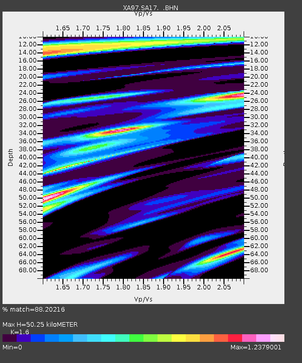
| Estimated Moho Depth: |
50.25 km |
| Estimated Crust Vp/Vs: |
1.60 |
| Assumed Crust Vp: |
6.612 km/s |
| Estimated Crust Vs: |
4.132 km/s |
| Estimated Crust Poisson's Ratio: |
0.18 |
|
| Radial Match: |
88.20216 % |
| Radial Bump: |
374 |
| Transverse Match: |
50.12508 % |
| Transverse Bump: |
400 |
| SOD ConfigId: |
4480 |
| Insert Time: |
2010-02-26 18:04:12.792 +0000 |
| GWidth: |
2.5 |
| Max Bumps: |
400 |
| Tol: |
0.001 |
|

Signal To Noise
| Channel | StoN | STA | LTA |
| XA:SA17: :BHN:19980618T04:24:47.699011Z | 3.4188957 | 3.6950266E-7 | 1.08076605E-7 |
| XA:SA17: :BHE:19980618T04:24:47.699011Z | 0.70886165 | 9.9579864E-8 | 1.4047856E-7 |
| XA:SA17: :BHZ:19980618T04:24:47.699011Z | 2.602997 | 4.0104499E-7 | 1.5407046E-7 |
| Arrivals |
| Ps | 5.0 SECOND |
| PpPs | 18 SECOND |
| PsPs/PpSs | 23 SECOND |


