You are here: Home > Network List > TA - USArray Transportable Network (new EarthScope stations) Stations List
> Station T33A Patterson Ranch, Waldron, KS, USA > Earthquake Result Viewer
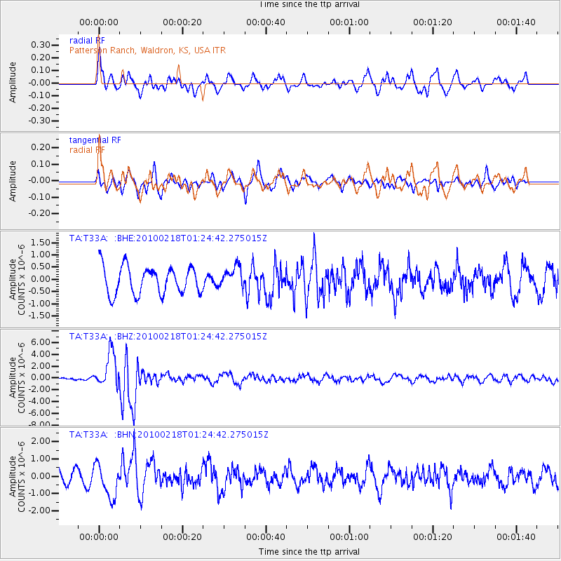
T33A Patterson Ranch, Waldron, KS, USA - Earthquake Result Viewer
*The percent match for this event was below the threshold and hence no stack was calculated.
| Earthquake location: |
E. Russia-N.E. China Border Reg. |
| Earthquake latitude/longitude: |
42.6/130.7 |
| Earthquake time(UTC): |
2010/02/18 (049) 01:13:19 GMT |
| Earthquake Depth: |
578 km |
| Earthquake Magnitude: |
6.3 MB, 6.9 MW, 6.9 MW |
| Earthquake Catalog/Contributor: |
WHDF/NEIC |
|
| Network: |
TA USArray Transportable Network (new EarthScope stations) |
| Station: |
T33A Patterson Ranch, Waldron, KS, USA |
| Lat/Lon: |
37.08 N/98.24 W |
| Elevation: |
394 m |
|
| Distance: |
89.0 deg |
| Az: |
37.096 deg |
| Baz: |
326.152 deg |
| Ray Param: |
$rayparam |
*The percent match for this event was below the threshold and hence was not used in the summary stack. |
|
| Radial Match: |
75.62189 % |
| Radial Bump: |
382 |
| Transverse Match: |
63.10212 % |
| Transverse Bump: |
391 |
| SOD ConfigId: |
306082 |
| Insert Time: |
2010-05-06 08:46:50.357 +0000 |
| GWidth: |
2.5 |
| Max Bumps: |
400 |
| Tol: |
0.001 |
|
Signal To Noise
| Channel | StoN | STA | LTA |
| TA:T33A: :BHZ:20100218T01:24:42.275015Z | 12.884146 | 3.0755145E-6 | 2.3870535E-7 |
| TA:T33A: :BHN:20100218T01:24:42.275015Z | 2.2191734 | 9.71871E-7 | 4.3794276E-7 |
| TA:T33A: :BHE:20100218T01:24:42.275015Z | 0.7686541 | 4.332173E-7 | 5.6360506E-7 |
| Arrivals |
| Ps | |
| PpPs | |
| PsPs/PpSs | |


