You are here: Home > Network List > TA - USArray Transportable Network (new EarthScope stations) Stations List
> Station U34A Anderson Ranch, Garber, OK, USA > Earthquake Result Viewer
U34A Anderson Ranch, Garber, OK, USA - Earthquake Result Viewer

| Earthquake location: |
E. Russia-N.E. China Border Reg. |
| Earthquake latitude/longitude: |
42.6/130.7 |
| Earthquake time(UTC): |
2010/02/18 (049) 01:13:19 GMT |
| Earthquake Depth: |
578 km |
| Earthquake Magnitude: |
6.3 MB, 6.9 MW, 6.9 MW |
| Earthquake Catalog/Contributor: |
WHDF/NEIC |
|
| Network: |
TA USArray Transportable Network (new EarthScope stations) |
| Station: |
U34A Anderson Ranch, Garber, OK, USA |
| Lat/Lon: |
36.44 N/97.54 W |
| Elevation: |
345 m |
|
| Distance: |
89.9 deg |
| Az: |
36.979 deg |
| Baz: |
326.573 deg |
| Ray Param: |
0.04151085 |
| Estimated Moho Depth: |
14.75 km |
| Estimated Crust Vp/Vs: |
1.60 |
| Assumed Crust Vp: |
6.483 km/s |
| Estimated Crust Vs: |
4.052 km/s |
| Estimated Crust Poisson's Ratio: |
0.18 |
|
| Radial Match: |
84.27167 % |
| Radial Bump: |
311 |
| Transverse Match: |
76.799675 % |
| Transverse Bump: |
370 |
| SOD ConfigId: |
306082 |
| Insert Time: |
2010-05-06 08:47:39.128 +0000 |
| GWidth: |
2.5 |
| Max Bumps: |
400 |
| Tol: |
0.001 |
|
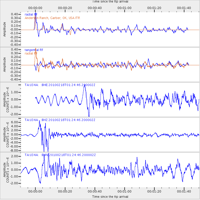
Signal To Noise
| Channel | StoN | STA | LTA |
| TA:U34A: :BHZ:20100218T01:24:46.200002Z | 9.610797 | 2.9643459E-6 | 3.0843913E-7 |
| TA:U34A: :BHN:20100218T01:24:46.200002Z | 3.1177003 | 9.539384E-7 | 3.0597502E-7 |
| TA:U34A: :BHE:20100218T01:24:46.200002Z | 2.6201987 | 1.016996E-6 | 3.8813695E-7 |
| Arrivals |
| Ps | 1.4 SECOND |
| PpPs | 5.8 SECOND |
| PsPs/PpSs | 7.2 SECOND |


