You are here: Home > Network List > AU - Australian Seismological Centre Stations List
> Station MEEK Meekatharra, Western Australia > Earthquake Result Viewer
MEEK Meekatharra, Western Australia - Earthquake Result Viewer
| Earthquake location: |
Solomon Islands |
| Earthquake latitude/longitude: |
-8.2/158.9 |
| Earthquake time(UTC): |
2023/03/27 (086) 22:19:15 GMT |
| Earthquake Depth: |
86 km |
| Earthquake Magnitude: |
6.1 mww |
| Earthquake Catalog/Contributor: |
NEIC PDE/us |
|
| Network: |
AU Australian Seismological Centre |
| Station: |
MEEK Meekatharra, Western Australia |
| Lat/Lon: |
26.64 S/118.61 E |
| Elevation: |
530 m |
|
| Distance: |
42.4 deg |
| Az: |
239.242 deg |
| Baz: |
71.875 deg |
| Ray Param: |
0.072948135 |
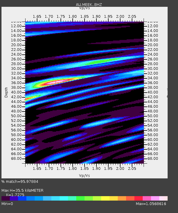
| Estimated Moho Depth: |
35.5 km |
| Estimated Crust Vp/Vs: |
1.73 |
| Assumed Crust Vp: |
6.459 km/s |
| Estimated Crust Vs: |
3.739 km/s |
| Estimated Crust Poisson's Ratio: |
0.25 |
|
| Radial Match: |
95.97884 % |
| Radial Bump: |
385 |
| Transverse Match: |
90.05498 % |
| Transverse Bump: |
400 |
| SOD ConfigId: |
30536071 |
| Insert Time: |
2023-04-10 22:25:19.189 +0000 |
| GWidth: |
2.5 |
| Max Bumps: |
400 |
| Tol: |
0.001 |
|

Signal To Noise
| Channel | StoN | STA | LTA |
| AU:MEEK: :BHZ:20230327T22:26:31.144014Z | 16.341496 | 3.0143733E-6 | 1.844613E-7 |
| AU:MEEK: :BHN:20230327T22:26:31.144014Z | 5.13418 | 7.24069E-7 | 1.4102915E-7 |
| AU:MEEK: :BHE:20230327T22:26:31.144014Z | 8.256873 | 1.5461543E-6 | 1.8725665E-7 |
| Arrivals |
| Ps | 4.3 SECOND |
| PpPs | 14 SECOND |
| PsPs/PpSs | 18 SECOND |


