You are here: Home > Network List > AV - Alaska Volcano Observatory Stations List
> Station KAWH Katmai, Alaska > Earthquake Result Viewer
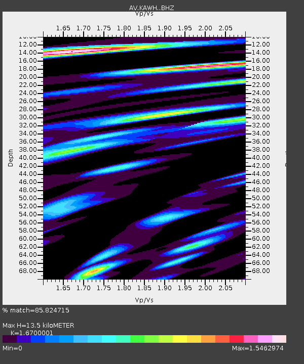
KAWH Katmai, Alaska - Earthquake Result Viewer
| Earthquake location: |
Solomon Islands |
| Earthquake latitude/longitude: |
-8.2/158.9 |
| Earthquake time(UTC): |
2023/03/27 (086) 22:19:15 GMT |
| Earthquake Depth: |
86 km |
| Earthquake Magnitude: |
6.1 mww |
| Earthquake Catalog/Contributor: |
NEIC PDE/us |
|
| Network: |
AV Alaska Volcano Observatory |
| Station: |
KAWH Katmai, Alaska |
| Lat/Lon: |
58.38 N/154.80 W |
| Elevation: |
777 m |
|
| Distance: |
76.1 deg |
| Az: |
23.087 deg |
| Baz: |
227.462 deg |
| Ray Param: |
0.05102276 |
| Estimated Moho Depth: |
13.5 km |
| Estimated Crust Vp/Vs: |
1.67 |
| Assumed Crust Vp: |
6.438 km/s |
| Estimated Crust Vs: |
3.855 km/s |
| Estimated Crust Poisson's Ratio: |
0.22 |
|
| Radial Match: |
85.824715 % |
| Radial Bump: |
400 |
| Transverse Match: |
80.87454 % |
| Transverse Bump: |
400 |
| SOD ConfigId: |
30536071 |
| Insert Time: |
2023-04-10 22:27:12.682 +0000 |
| GWidth: |
2.5 |
| Max Bumps: |
400 |
| Tol: |
0.001 |
|

Signal To Noise
| Channel | StoN | STA | LTA |
| AV:KAWH: :BHZ:20230327T22:30:23.35901Z | 10.878402 | 1.1330875E-6 | 1.04159376E-7 |
| AV:KAWH: :BHN:20230327T22:30:23.35901Z | 3.705851 | 3.5243514E-7 | 9.510235E-8 |
| AV:KAWH: :BHE:20230327T22:30:23.35901Z | 6.382972 | 7.613053E-7 | 1.1927129E-7 |
| Arrivals |
| Ps | 1.5 SECOND |
| PpPs | 5.4 SECOND |
| PsPs/PpSs | 6.9 SECOND |


