You are here: Home > Network List > CI - Caltech Regional Seismic Network Stations List
> Station TUQ Turquiose Mountain, Baker, CA, USA > Earthquake Result Viewer
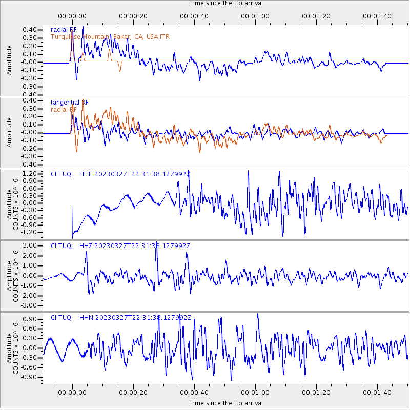
TUQ Turquiose Mountain, Baker, CA, USA - Earthquake Result Viewer
*The percent match for this event was below the threshold and hence no stack was calculated.
| Earthquake location: |
Solomon Islands |
| Earthquake latitude/longitude: |
-8.2/158.9 |
| Earthquake time(UTC): |
2023/03/27 (086) 22:19:15 GMT |
| Earthquake Depth: |
86 km |
| Earthquake Magnitude: |
6.1 mww |
| Earthquake Catalog/Contributor: |
NEIC PDE/us |
|
| Network: |
CI Caltech Regional Seismic Network |
| Station: |
TUQ Turquiose Mountain, Baker, CA, USA |
| Lat/Lon: |
35.44 N/115.92 W |
| Elevation: |
1350 m |
|
| Distance: |
90.8 deg |
| Az: |
54.464 deg |
| Baz: |
260.55 deg |
| Ray Param: |
$rayparam |
*The percent match for this event was below the threshold and hence was not used in the summary stack. |
|
| Radial Match: |
53.177425 % |
| Radial Bump: |
400 |
| Transverse Match: |
72.133316 % |
| Transverse Bump: |
400 |
| SOD ConfigId: |
30536071 |
| Insert Time: |
2023-04-10 22:33:04.201 +0000 |
| GWidth: |
2.5 |
| Max Bumps: |
400 |
| Tol: |
0.001 |
|
Signal To Noise
| Channel | StoN | STA | LTA |
| CI:TUQ: :HHZ:20230327T22:31:38.127992Z | 3.3876114 | 8.22099E-7 | 2.4267808E-7 |
| CI:TUQ: :HHN:20230327T22:31:38.127992Z | 0.68438065 | 1.8891396E-7 | 2.760364E-7 |
| CI:TUQ: :HHE:20230327T22:31:38.127992Z | 1.340393 | 5.99182E-7 | 4.4701963E-7 |
| Arrivals |
| Ps | |
| PpPs | |
| PsPs/PpSs | |


