You are here: Home > Network List > G - GEOSCOPE Stations List
> Station INU Inuyama, Japan > Earthquake Result Viewer
INU Inuyama, Japan - Earthquake Result Viewer
| Earthquake location: |
Solomon Islands |
| Earthquake latitude/longitude: |
-8.2/158.9 |
| Earthquake time(UTC): |
2023/03/27 (086) 22:19:15 GMT |
| Earthquake Depth: |
86 km |
| Earthquake Magnitude: |
6.1 mww |
| Earthquake Catalog/Contributor: |
NEIC PDE/us |
|
| Network: |
G GEOSCOPE |
| Station: |
INU Inuyama, Japan |
| Lat/Lon: |
35.35 N/137.03 E |
| Elevation: |
132 m |
|
| Distance: |
48.0 deg |
| Az: |
335.781 deg |
| Baz: |
150.214 deg |
| Ray Param: |
0.06937176 |
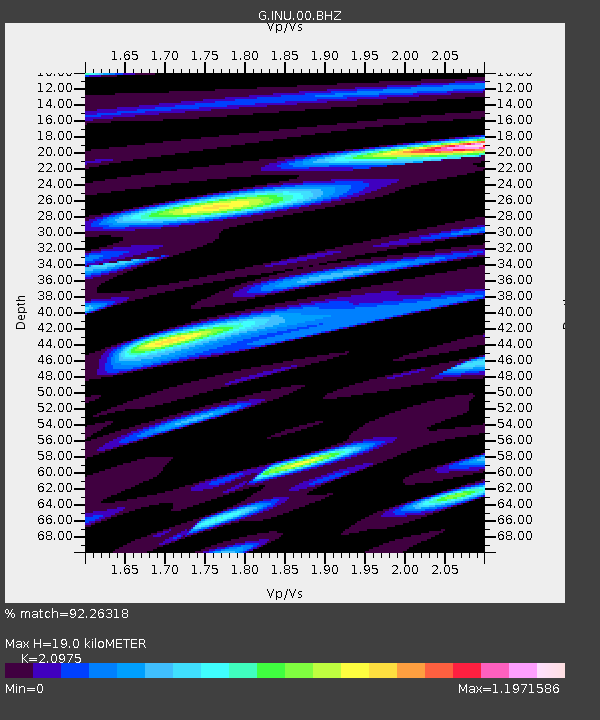
| Estimated Moho Depth: |
19.0 km |
| Estimated Crust Vp/Vs: |
2.10 |
| Assumed Crust Vp: |
6.461 km/s |
| Estimated Crust Vs: |
3.081 km/s |
| Estimated Crust Poisson's Ratio: |
0.35 |
|
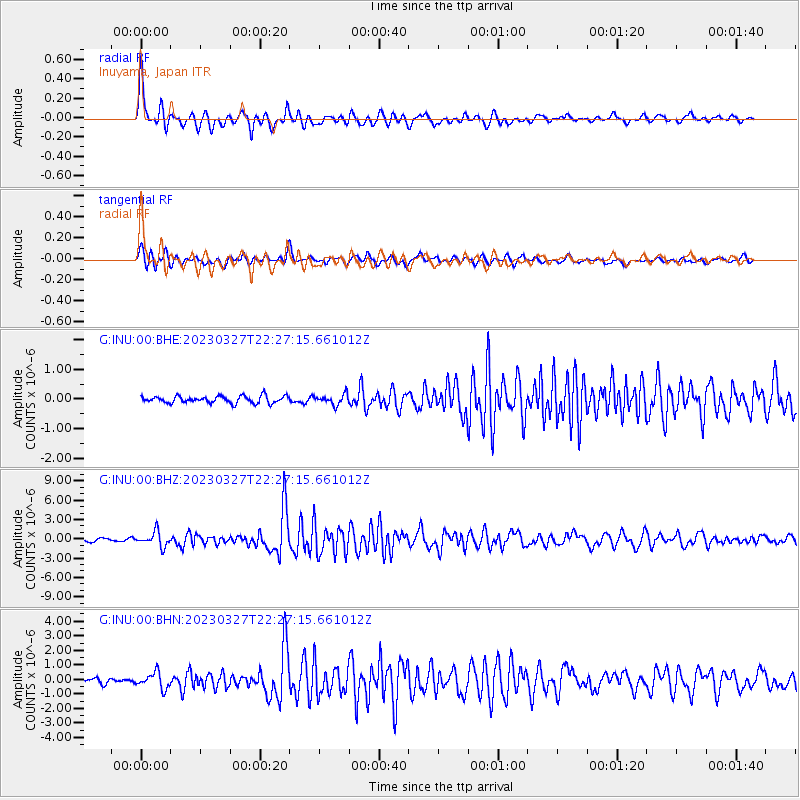
| Radial Match: |
92.26318 % |
| Radial Bump: |
400 |
| Transverse Match: |
88.36569 % |
| Transverse Bump: |
400 |
| SOD ConfigId: |
30536071 |
| Insert Time: |
2023-04-10 22:34:51.390 +0000 |
| GWidth: |
2.5 |
| Max Bumps: |
400 |
| Tol: |
0.001 |
|
Signal To Noise
| Channel | StoN | STA | LTA |
| G:INU:00:BHZ:20230327T22:27:15.661012Z | 6.224743 | 1.1352952E-6 | 1.8238428E-7 |
| G:INU:00:BHN:20230327T22:27:15.661012Z | 3.7185497 | 5.470169E-7 | 1.4710491E-7 |
| G:INU:00:BHE:20230327T22:27:15.661012Z | 1.4674606 | 1.722686E-7 | 1.1739232E-7 |
| Arrivals |
| Ps | 3.4 SECOND |
| PpPs | 8.7 SECOND |
| PsPs/PpSs | 12 SECOND |


