You are here: Home > Network List > IW - Intermountain West Stations List
> Station PLID Pearl Lake, Idaho, USA > Earthquake Result Viewer
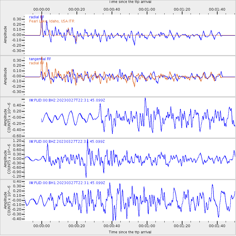
PLID Pearl Lake, Idaho, USA - Earthquake Result Viewer
*The percent match for this event was below the threshold and hence no stack was calculated.
| Earthquake location: |
Solomon Islands |
| Earthquake latitude/longitude: |
-8.2/158.9 |
| Earthquake time(UTC): |
2023/03/27 (086) 22:19:15 GMT |
| Earthquake Depth: |
86 km |
| Earthquake Magnitude: |
6.1 mww |
| Earthquake Catalog/Contributor: |
NEIC PDE/us |
|
| Network: |
IW Intermountain West |
| Station: |
PLID Pearl Lake, Idaho, USA |
| Lat/Lon: |
45.09 N/116.00 W |
| Elevation: |
2164 m |
|
| Distance: |
92.3 deg |
| Az: |
44.938 deg |
| Baz: |
260.756 deg |
| Ray Param: |
$rayparam |
*The percent match for this event was below the threshold and hence was not used in the summary stack. |
|
| Radial Match: |
62.31766 % |
| Radial Bump: |
400 |
| Transverse Match: |
56.227745 % |
| Transverse Bump: |
400 |
| SOD ConfigId: |
30536071 |
| Insert Time: |
2023-04-10 22:36:22.687 +0000 |
| GWidth: |
2.5 |
| Max Bumps: |
400 |
| Tol: |
0.001 |
|
Signal To Noise
| Channel | StoN | STA | LTA |
| IW:PLID:00:BHZ:20230327T22:31:45.099Z | 2.00212 | 3.412557E-7 | 1.7044718E-7 |
| IW:PLID:00:BH1:20230327T22:31:45.099Z | 0.89663243 | 7.606804E-8 | 8.483748E-8 |
| IW:PLID:00:BH2:20230327T22:31:45.099Z | 1.4431107 | 1.6851172E-7 | 1.1676978E-7 |
| Arrivals |
| Ps | |
| PpPs | |
| PsPs/PpSs | |


