You are here: Home > Network List > US - United States National Seismic Network Stations List
> Station EGMT Eagleton, Montana, USA > Earthquake Result Viewer
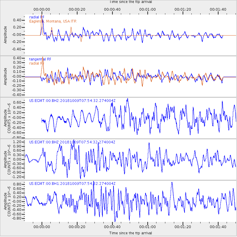
EGMT Eagleton, Montana, USA - Earthquake Result Viewer
*The percent match for this event was below the threshold and hence no stack was calculated.
| Earthquake location: |
Kuril Islands |
| Earthquake latitude/longitude: |
49.4/156.2 |
| Earthquake time(UTC): |
2018/10/09 (282) 07:45:14 GMT |
| Earthquake Depth: |
42 km |
| Earthquake Magnitude: |
6.0 Mww |
| Earthquake Catalog/Contributor: |
NEIC PDE/us |
|
| Network: |
US United States National Seismic Network |
| Station: |
EGMT Eagleton, Montana, USA |
| Lat/Lon: |
48.02 N/109.75 W |
| Elevation: |
1055 m |
|
| Distance: |
58.0 deg |
| Az: |
52.165 deg |
| Baz: |
309.814 deg |
| Ray Param: |
$rayparam |
*The percent match for this event was below the threshold and hence was not used in the summary stack. |
|
| Radial Match: |
74.11363 % |
| Radial Bump: |
400 |
| Transverse Match: |
64.512184 % |
| Transverse Bump: |
400 |
| SOD ConfigId: |
3045211 |
| Insert Time: |
2018-10-23 08:04:48.898 +0000 |
| GWidth: |
2.5 |
| Max Bumps: |
400 |
| Tol: |
0.001 |
|
Signal To Noise
| Channel | StoN | STA | LTA |
| US:EGMT:00:BHZ:20181009T07:54:32.274004Z | 3.1847317 | 4.4374315E-7 | 1.3933455E-7 |
| US:EGMT:00:BH1:20181009T07:54:32.274004Z | 0.941877 | 1.6925205E-7 | 1.7969654E-7 |
| US:EGMT:00:BH2:20181009T07:54:32.274004Z | 1.4727278 | 2.838267E-7 | 1.9272176E-7 |
| Arrivals |
| Ps | |
| PpPs | |
| PsPs/PpSs | |


