You are here: Home > Network List > US - United States National Seismic Network Stations List
> Station AMTX Amarillo, Texas, USA > Earthquake Result Viewer
AMTX Amarillo, Texas, USA - Earthquake Result Viewer
*The percent match for this event was below the threshold and hence no stack was calculated.
| Earthquake location: |
E. Russia-N.E. China Border Reg. |
| Earthquake latitude/longitude: |
42.6/130.7 |
| Earthquake time(UTC): |
2010/02/18 (049) 01:13:19 GMT |
| Earthquake Depth: |
578 km |
| Earthquake Magnitude: |
6.3 MB, 6.9 MW, 6.9 MW |
| Earthquake Catalog/Contributor: |
WHDF/NEIC |
|
| Network: |
US United States National Seismic Network |
| Station: |
AMTX Amarillo, Texas, USA |
| Lat/Lon: |
34.53 N/101.41 W |
| Elevation: |
1010 m |
|
| Distance: |
89.7 deg |
| Az: |
40.661 deg |
| Baz: |
324.349 deg |
| Ray Param: |
$rayparam |
*The percent match for this event was below the threshold and hence was not used in the summary stack. |
|
| Radial Match: |
69.050125 % |
| Radial Bump: |
400 |
| Transverse Match: |
59.93508 % |
| Transverse Bump: |
400 |
| SOD ConfigId: |
306082 |
| Insert Time: |
2010-05-06 08:56:29.969 +0000 |
| GWidth: |
2.5 |
| Max Bumps: |
400 |
| Tol: |
0.001 |
|
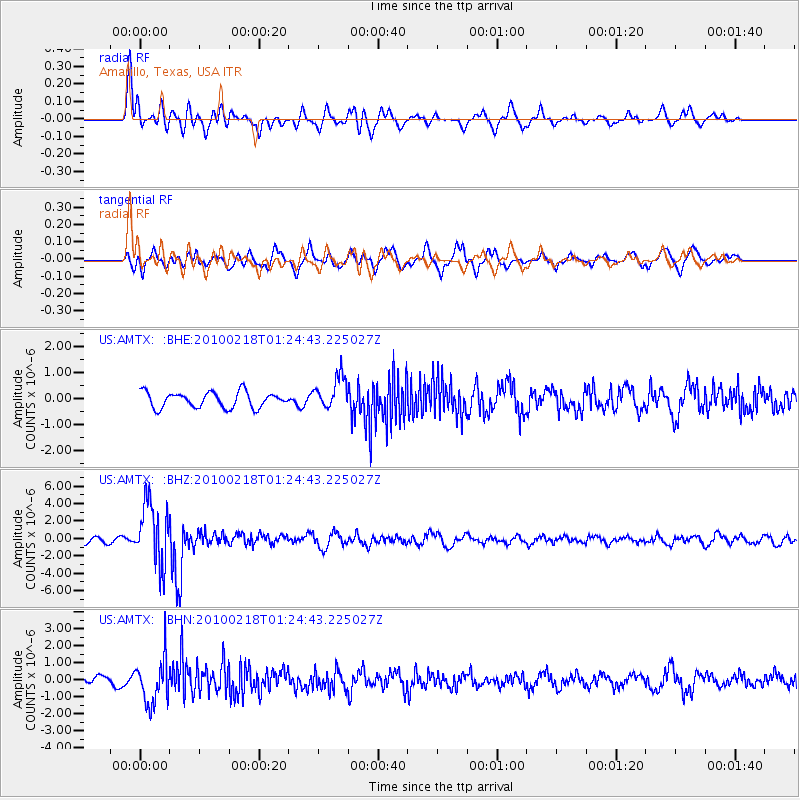
Signal To Noise
| Channel | StoN | STA | LTA |
| US:AMTX: :BHZ:20100218T01:24:43.225027Z | 13.557274 | 3.5473852E-6 | 2.6165918E-7 |
| US:AMTX: :BHN:20100218T01:24:43.225027Z | 4.0741568 | 1.3328734E-6 | 3.2715317E-7 |
| US:AMTX: :BHE:20100218T01:24:43.225027Z | 2.580279 | 7.19819E-7 | 2.7896942E-7 |
| Arrivals |
| Ps | |
| PpPs | |
| PsPs/PpSs | |


