You are here: Home > Network List > US - United States National Seismic Network Stations List
> Station HAWA Hanford, Washington, USA > Earthquake Result Viewer
HAWA Hanford, Washington, USA - Earthquake Result Viewer
*The percent match for this event was below the threshold and hence no stack was calculated.
| Earthquake location: |
Solomon Islands |
| Earthquake latitude/longitude: |
-8.2/158.9 |
| Earthquake time(UTC): |
2023/03/27 (086) 22:19:15 GMT |
| Earthquake Depth: |
86 km |
| Earthquake Magnitude: |
6.1 mww |
| Earthquake Catalog/Contributor: |
NEIC PDE/us |
|
| Network: |
US United States National Seismic Network |
| Station: |
HAWA Hanford, Washington, USA |
| Lat/Lon: |
46.39 N/119.53 W |
| Elevation: |
364 m |
|
| Distance: |
90.1 deg |
| Az: |
43.205 deg |
| Baz: |
258.27 deg |
| Ray Param: |
$rayparam |
*The percent match for this event was below the threshold and hence was not used in the summary stack. |
|
| Radial Match: |
53.08658 % |
| Radial Bump: |
400 |
| Transverse Match: |
48.170086 % |
| Transverse Bump: |
400 |
| SOD ConfigId: |
30536071 |
| Insert Time: |
2023-04-10 22:43:38.732 +0000 |
| GWidth: |
2.5 |
| Max Bumps: |
400 |
| Tol: |
0.001 |
|
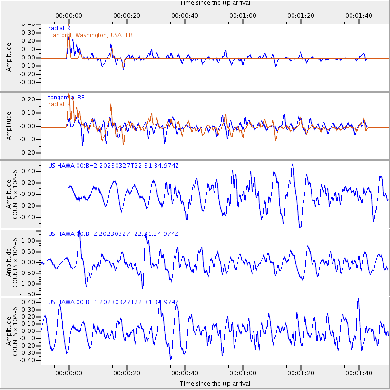
Signal To Noise
| Channel | StoN | STA | LTA |
| US:HAWA:00:BHZ:20230327T22:31:34.974Z | 5.8410363 | 5.73812E-7 | 9.823804E-8 |
| US:HAWA:00:BH1:20230327T22:31:34.974Z | 1.209705 | 1.2889646E-7 | 1.0655199E-7 |
| US:HAWA:00:BH2:20230327T22:31:34.974Z | 1.2456771 | 1.4458143E-7 | 1.16066545E-7 |
| Arrivals |
| Ps | |
| PpPs | |
| PsPs/PpSs | |


