You are here: Home > Network List > WY - Yellowstone Wyoming Seismic Network Stations List
> Station YUF Upper Falls, WY, USA > Earthquake Result Viewer
YUF Upper Falls, WY, USA - Earthquake Result Viewer
*The percent match for this event was below the threshold and hence no stack was calculated.
| Earthquake location: |
Solomon Islands |
| Earthquake latitude/longitude: |
-8.2/158.9 |
| Earthquake time(UTC): |
2023/03/27 (086) 22:19:15 GMT |
| Earthquake Depth: |
86 km |
| Earthquake Magnitude: |
6.1 mww |
| Earthquake Catalog/Contributor: |
NEIC PDE/us |
|
| Network: |
WY Yellowstone Wyoming Seismic Network |
| Station: |
YUF Upper Falls, WY, USA |
| Lat/Lon: |
44.71 N/110.51 W |
| Elevation: |
2394 m |
|
| Distance: |
96.1 deg |
| Az: |
45.811 deg |
| Baz: |
264.555 deg |
| Ray Param: |
$rayparam |
*The percent match for this event was below the threshold and hence was not used in the summary stack. |
|
| Radial Match: |
49.405518 % |
| Radial Bump: |
400 |
| Transverse Match: |
54.416527 % |
| Transverse Bump: |
400 |
| SOD ConfigId: |
30536071 |
| Insert Time: |
2023-04-10 22:47:49.818 +0000 |
| GWidth: |
2.5 |
| Max Bumps: |
400 |
| Tol: |
0.001 |
|
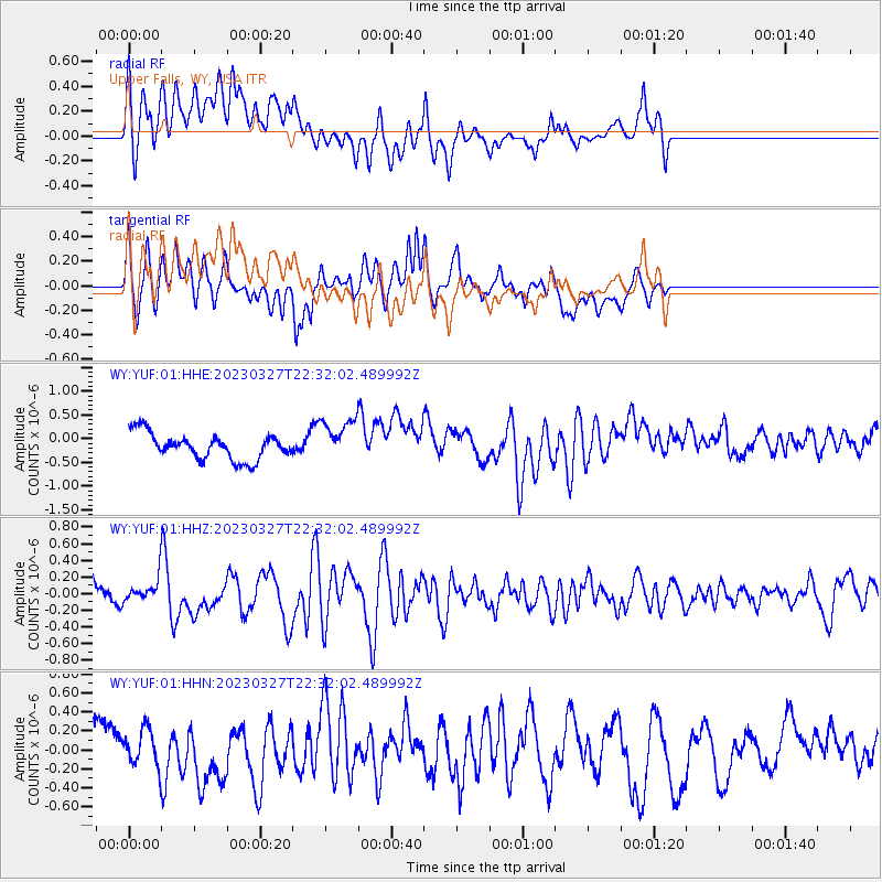
Signal To Noise
| Channel | StoN | STA | LTA |
| WY:YUF:01:HHZ:20230327T22:32:02.489992Z | 0.8078605 | 1.2510552E-7 | 1.5486029E-7 |
| WY:YUF:01:HHN:20230327T22:32:02.489992Z | 0.69089 | 2.0294637E-7 | 2.9374627E-7 |
| WY:YUF:01:HHE:20230327T22:32:02.489992Z | 1.6546116 | 4.4999084E-7 | 2.7196162E-7 |
| Arrivals |
| Ps | |
| PpPs | |
| PsPs/PpSs | |


