You are here: Home > Network List > XA97 - Anatomy of an Archean Craton, South Africa Stations List
> Station SA17 XA.SA17 > Earthquake Result Viewer
SA17 XA.SA17 - Earthquake Result Viewer
| Earthquake location: |
South Sandwich Islands Region |
| Earthquake latitude/longitude: |
-59.7/-29.2 |
| Earthquake time(UTC): |
1997/10/05 (278) 18:04:30 GMT |
| Earthquake Depth: |
274 km |
| Earthquake Magnitude: |
6.0 MB, 6.3 UNKNOWN, 6.3 MW |
| Earthquake Catalog/Contributor: |
WHDF/NEIC |
|
| Network: |
XA Anatomy of an Archean Craton, South Africa |
| Station: |
SA17 XA.SA17 |
| Lat/Lon: |
28.93 S/23.23 E |
| Elevation: |
1249 m |
|
| Distance: |
46.7 deg |
| Az: |
72.641 deg |
| Baz: |
213.468 deg |
| Ray Param: |
0.069388 |
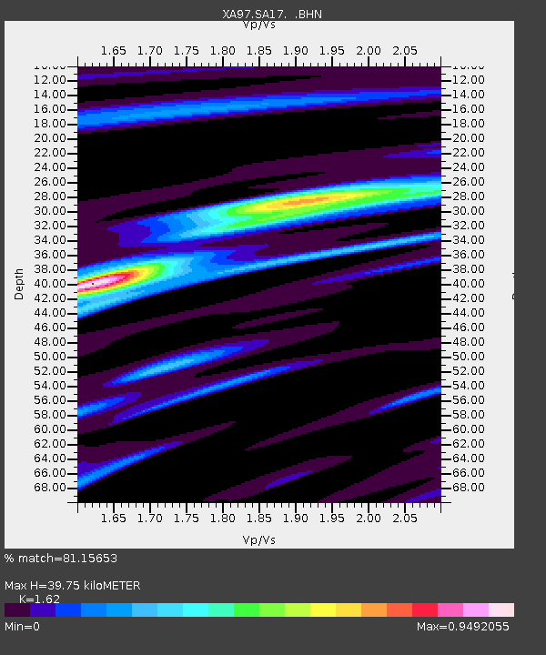
| Estimated Moho Depth: |
39.75 km |
| Estimated Crust Vp/Vs: |
1.62 |
| Assumed Crust Vp: |
6.612 km/s |
| Estimated Crust Vs: |
4.081 km/s |
| Estimated Crust Poisson's Ratio: |
0.19 |
|
| Radial Match: |
81.15653 % |
| Radial Bump: |
400 |
| Transverse Match: |
63.955135 % |
| Transverse Bump: |
400 |
| SOD ConfigId: |
6273 |
| Insert Time: |
2010-02-26 18:04:24.644 +0000 |
| GWidth: |
2.5 |
| Max Bumps: |
400 |
| Tol: |
0.001 |
|
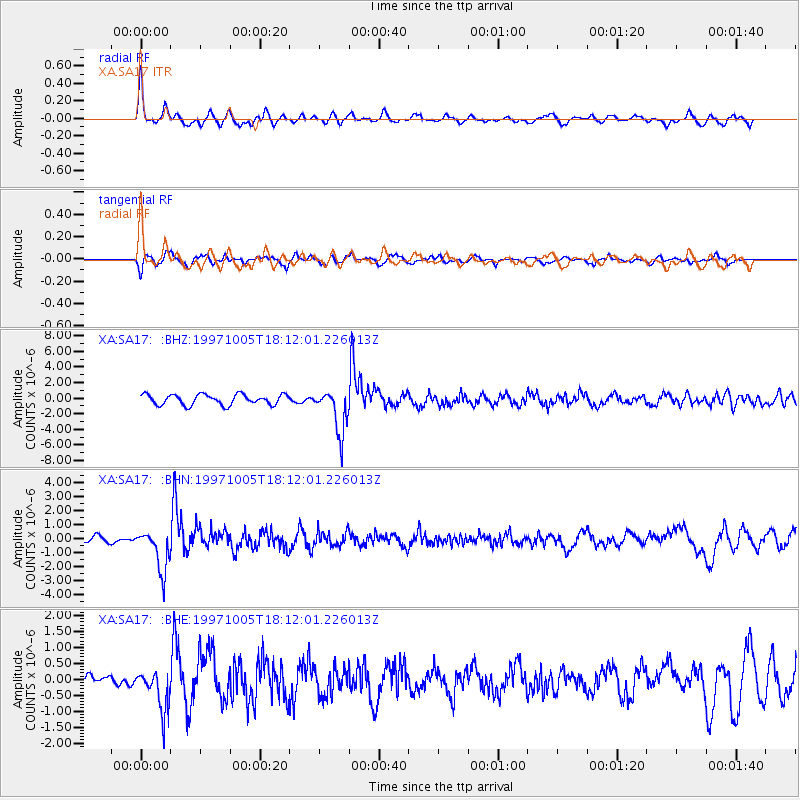
Signal To Noise
| Channel | StoN | STA | LTA |
| XA:SA17: :BHN:19971005T18:12:01.226013Z | 4.688854 | 1.4842076E-6 | 3.165395E-7 |
| XA:SA17: :BHE:19971005T18:12:01.226013Z | 2.8344798 | 6.4172224E-7 | 2.263986E-7 |
| XA:SA17: :BHZ:19971005T18:12:01.226013Z | 4.265738 | 2.83244E-6 | 6.6399764E-7 |
| Arrivals |
| Ps | 4.0 SECOND |
| PpPs | 15 SECOND |
| PsPs/PpSs | 19 SECOND |


