You are here: Home > Network List > AK - Alaska Regional Network Stations List
> Station L20K Alaska Regional Network > Earthquake Result Viewer
L20K Alaska Regional Network - Earthquake Result Viewer
| Earthquake location: |
Hokkaido, Japan Region |
| Earthquake latitude/longitude: |
41.1/142.8 |
| Earthquake time(UTC): |
2023/03/28 (087) 09:18:27 GMT |
| Earthquake Depth: |
31 km |
| Earthquake Magnitude: |
6.2 Mww |
| Earthquake Catalog/Contributor: |
NEIC PDE/us |
|
| Network: |
AK Alaska Regional Network |
| Station: |
L20K Alaska Regional Network |
| Lat/Lon: |
62.48 N/153.88 W |
| Elevation: |
673 m |
|
| Distance: |
42.4 deg |
| Az: |
37.958 deg |
| Baz: |
270.358 deg |
| Ray Param: |
0.07312247 |
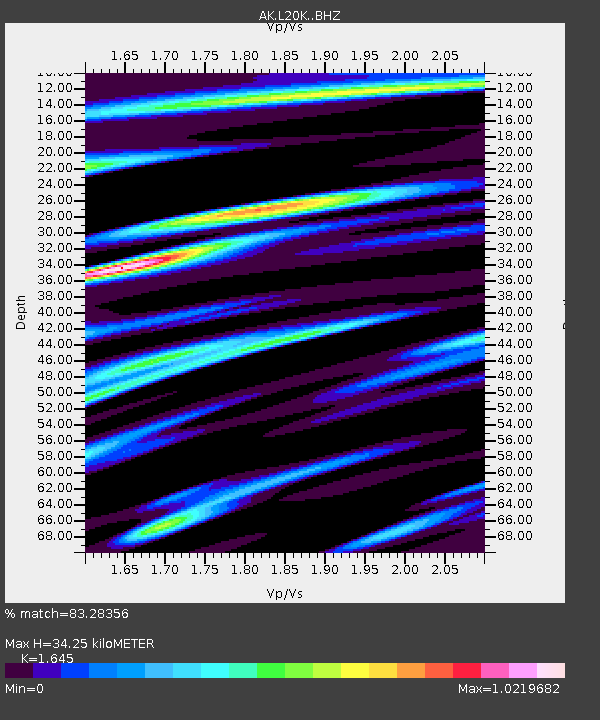
| Estimated Moho Depth: |
34.25 km |
| Estimated Crust Vp/Vs: |
1.64 |
| Assumed Crust Vp: |
6.566 km/s |
| Estimated Crust Vs: |
3.992 km/s |
| Estimated Crust Poisson's Ratio: |
0.21 |
|
| Radial Match: |
83.28356 % |
| Radial Bump: |
350 |
| Transverse Match: |
59.601696 % |
| Transverse Bump: |
400 |
| SOD ConfigId: |
30536071 |
| Insert Time: |
2023-04-11 09:22:32.843 +0000 |
| GWidth: |
2.5 |
| Max Bumps: |
400 |
| Tol: |
0.001 |
|

Signal To Noise
| Channel | StoN | STA | LTA |
| AK:L20K: :BHZ:20230328T09:25:49.120007Z | 1.7685785 | 3.3341382E-7 | 1.8852079E-7 |
| AK:L20K: :BHN:20230328T09:25:49.120007Z | 1.3389744 | 1.6409042E-7 | 1.2254934E-7 |
| AK:L20K: :BHE:20230328T09:25:49.120007Z | 2.2728603 | 2.8943683E-7 | 1.2734476E-7 |
| Arrivals |
| Ps | 3.6 SECOND |
| PpPs | 13 SECOND |
| PsPs/PpSs | 16 SECOND |


