You are here: Home > Network List > AV - Alaska Volcano Observatory Stations List
> Station SPU Mount Spurr, Mount Spurr, Alaska > Earthquake Result Viewer
SPU Mount Spurr, Mount Spurr, Alaska - Earthquake Result Viewer

| Earthquake location: |
Hokkaido, Japan Region |
| Earthquake latitude/longitude: |
41.1/142.8 |
| Earthquake time(UTC): |
2023/03/28 (087) 09:18:27 GMT |
| Earthquake Depth: |
31 km |
| Earthquake Magnitude: |
6.2 Mww |
| Earthquake Catalog/Contributor: |
NEIC PDE/us |
|
| Network: |
AV Alaska Volcano Observatory |
| Station: |
SPU Mount Spurr, Mount Spurr, Alaska |
| Lat/Lon: |
61.18 N/152.06 W |
| Elevation: |
800 m |
|
| Distance: |
43.3 deg |
| Az: |
39.829 deg |
| Baz: |
273.334 deg |
| Ray Param: |
0.07255142 |
| Estimated Moho Depth: |
12.5 km |
| Estimated Crust Vp/Vs: |
2.02 |
| Assumed Crust Vp: |
6.566 km/s |
| Estimated Crust Vs: |
3.247 km/s |
| Estimated Crust Poisson's Ratio: |
0.34 |
|
| Radial Match: |
88.38085 % |
| Radial Bump: |
400 |
| Transverse Match: |
76.33249 % |
| Transverse Bump: |
400 |
| SOD ConfigId: |
30536071 |
| Insert Time: |
2023-04-11 09:26:20.864 +0000 |
| GWidth: |
2.5 |
| Max Bumps: |
400 |
| Tol: |
0.001 |
|
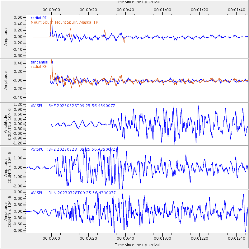
Signal To Noise
| Channel | StoN | STA | LTA |
| AV:SPU: :BHZ:20230328T09:25:56.439007Z | 6.125741 | 5.015055E-7 | 8.186855E-8 |
| AV:SPU: :BHN:20230328T09:25:56.439007Z | 1.3035945 | 1.1513825E-7 | 8.8323674E-8 |
| AV:SPU: :BHE:20230328T09:25:56.439007Z | 1.2192637 | 1.3532642E-7 | 1.1099028E-7 |
| Arrivals |
| Ps | 2.1 SECOND |
| PpPs | 5.4 SECOND |
| PsPs/PpSs | 7.5 SECOND |


