You are here: Home > Network List > BK - Berkeley Digital Seismograph Network Stations List
> Station HUMO Hull Mountain, OR > Earthquake Result Viewer
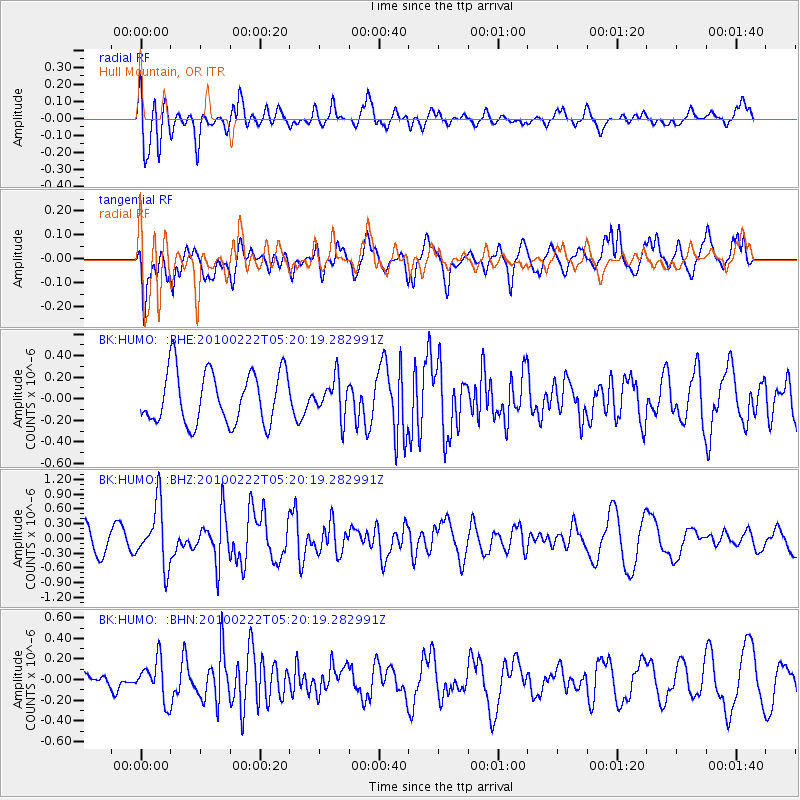
HUMO Hull Mountain, OR - Earthquake Result Viewer
*The percent match for this event was below the threshold and hence no stack was calculated.
| Earthquake location: |
Tonga Islands |
| Earthquake latitude/longitude: |
-21.5/-173.8 |
| Earthquake time(UTC): |
2010/02/22 (053) 05:08:49 GMT |
| Earthquake Depth: |
33 km |
| Earthquake Magnitude: |
5.8 MB, 5.3 MS, 5.7 MW, 5.7 MW |
| Earthquake Catalog/Contributor: |
WHDF/NEIC |
|
| Network: |
BK Berkeley Digital Seismograph Network |
| Station: |
HUMO Hull Mountain, OR |
| Lat/Lon: |
42.61 N/122.96 W |
| Elevation: |
555 m |
|
| Distance: |
79.1 deg |
| Az: |
35.643 deg |
| Baz: |
227.307 deg |
| Ray Param: |
$rayparam |
*The percent match for this event was below the threshold and hence was not used in the summary stack. |
|
| Radial Match: |
63.727665 % |
| Radial Bump: |
400 |
| Transverse Match: |
59.933346 % |
| Transverse Bump: |
400 |
| SOD ConfigId: |
307546 |
| Insert Time: |
2010-05-14 06:39:36.618 +0000 |
| GWidth: |
2.5 |
| Max Bumps: |
400 |
| Tol: |
0.001 |
|
Signal To Noise
| Channel | StoN | STA | LTA |
| BK:HUMO: :BHZ:20100222T05:20:19.282991Z | 2.9559147 | 6.1460383E-7 | 2.079234E-7 |
| BK:HUMO: :BHN:20100222T05:20:19.282991Z | 1.0816967 | 1.9273322E-7 | 1.7817675E-7 |
| BK:HUMO: :BHE:20100222T05:20:19.282991Z | 0.7222384 | 1.7445566E-7 | 2.415486E-7 |
| Arrivals |
| Ps | |
| PpPs | |
| PsPs/PpSs | |


