You are here: Home > Network List > GM - US Geological Survey Networks Stations List
> Station IWM01 Jericho 2M Well Monitoring Station > Earthquake Result Viewer
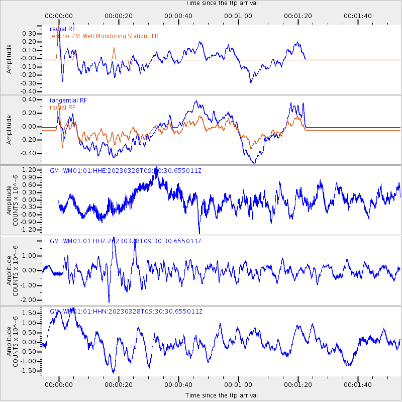
IWM01 Jericho 2M Well Monitoring Station - Earthquake Result Viewer
*The percent match for this event was below the threshold and hence no stack was calculated.
| Earthquake location: |
Hokkaido, Japan Region |
| Earthquake latitude/longitude: |
41.1/142.8 |
| Earthquake time(UTC): |
2023/03/28 (087) 09:18:27 GMT |
| Earthquake Depth: |
31 km |
| Earthquake Magnitude: |
6.2 Mww |
| Earthquake Catalog/Contributor: |
NEIC PDE/us |
|
| Network: |
GM US Geological Survey Networks |
| Station: |
IWM01 Jericho 2M Well Monitoring Station |
| Lat/Lon: |
36.73 N/96.53 W |
| Elevation: |
328 m |
|
| Distance: |
85.4 deg |
| Az: |
43.892 deg |
| Baz: |
319.33 deg |
| Ray Param: |
$rayparam |
*The percent match for this event was below the threshold and hence was not used in the summary stack. |
|
| Radial Match: |
39.761 % |
| Radial Bump: |
400 |
| Transverse Match: |
41.890503 % |
| Transverse Bump: |
400 |
| SOD ConfigId: |
30536071 |
| Insert Time: |
2023-04-11 09:33:45.466 +0000 |
| GWidth: |
2.5 |
| Max Bumps: |
400 |
| Tol: |
0.001 |
|
Signal To Noise
| Channel | StoN | STA | LTA |
| GM:IWM01:01:HHZ:20230328T09:30:30.655011Z | 2.4148524 | 4.4031214E-7 | 1.8233501E-7 |
| GM:IWM01:01:HHN:20230328T09:30:30.655011Z | 4.2028317 | 1.8294569E-6 | 4.352915E-7 |
| GM:IWM01:01:HHE:20230328T09:30:30.655011Z | 4.441238 | 1.1131746E-6 | 2.506451E-7 |
| Arrivals |
| Ps | |
| PpPs | |
| PsPs/PpSs | |


