You are here: Home > Network List > IU - Global Seismograph Network (GSN - IRIS/USGS) Stations List
> Station KMBO Kilima Mbogo, Kenya > Earthquake Result Viewer
KMBO Kilima Mbogo, Kenya - Earthquake Result Viewer
| Earthquake location: |
Bali Sea |
| Earthquake latitude/longitude: |
-7.4/114.5 |
| Earthquake time(UTC): |
2018/10/10 (283) 18:44:55 GMT |
| Earthquake Depth: |
10 km |
| Earthquake Magnitude: |
6.0 Mww |
| Earthquake Catalog/Contributor: |
NEIC PDE/us |
|
| Network: |
IU Global Seismograph Network (GSN - IRIS/USGS) |
| Station: |
KMBO Kilima Mbogo, Kenya |
| Lat/Lon: |
1.13 S/37.25 E |
| Elevation: |
1950 m |
|
| Distance: |
77.2 deg |
| Az: |
270.538 deg |
| Baz: |
97.335 deg |
| Ray Param: |
0.050507877 |
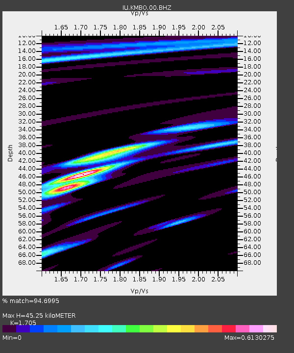
| Estimated Moho Depth: |
45.25 km |
| Estimated Crust Vp/Vs: |
1.71 |
| Assumed Crust Vp: |
6.601 km/s |
| Estimated Crust Vs: |
3.871 km/s |
| Estimated Crust Poisson's Ratio: |
0.24 |
|
| Radial Match: |
94.6995 % |
| Radial Bump: |
400 |
| Transverse Match: |
74.195564 % |
| Transverse Bump: |
400 |
| SOD ConfigId: |
3045211 |
| Insert Time: |
2018-10-24 18:48:15.130 +0000 |
| GWidth: |
2.5 |
| Max Bumps: |
400 |
| Tol: |
0.001 |
|

Signal To Noise
| Channel | StoN | STA | LTA |
| IU:KMBO:00:BHZ:20181010T18:56:17.869028Z | 28.386784 | 1.6969002E-6 | 5.9777825E-8 |
| IU:KMBO:00:BH1:20181010T18:56:17.869028Z | 3.4111598 | 2.304762E-7 | 6.756535E-8 |
| IU:KMBO:00:BH2:20181010T18:56:17.869028Z | 11.147861 | 6.6443533E-7 | 5.9602048E-8 |
| Arrivals |
| Ps | 5.0 SECOND |
| PpPs | 18 SECOND |
| PsPs/PpSs | 23 SECOND |


