You are here: Home > Network List > IU - Global Seismograph Network (GSN - IRIS/USGS) Stations List
> Station MAKZ Makanchi, Kazakhstan > Earthquake Result Viewer
MAKZ Makanchi, Kazakhstan - Earthquake Result Viewer

| Earthquake location: |
Hokkaido, Japan Region |
| Earthquake latitude/longitude: |
41.1/142.8 |
| Earthquake time(UTC): |
2023/03/28 (087) 09:18:27 GMT |
| Earthquake Depth: |
31 km |
| Earthquake Magnitude: |
6.2 Mww |
| Earthquake Catalog/Contributor: |
NEIC PDE/us |
|
| Network: |
IU Global Seismograph Network (GSN - IRIS/USGS) |
| Station: |
MAKZ Makanchi, Kazakhstan |
| Lat/Lon: |
46.81 N/81.98 E |
| Elevation: |
600 m |
|
| Distance: |
43.2 deg |
| Az: |
298.775 deg |
| Baz: |
74.516 deg |
| Ray Param: |
0.07266374 |
| Estimated Moho Depth: |
50.25 km |
| Estimated Crust Vp/Vs: |
1.73 |
| Assumed Crust Vp: |
6.571 km/s |
| Estimated Crust Vs: |
3.793 km/s |
| Estimated Crust Poisson's Ratio: |
0.25 |
|
| Radial Match: |
96.43543 % |
| Radial Bump: |
382 |
| Transverse Match: |
86.3679 % |
| Transverse Bump: |
400 |
| SOD ConfigId: |
30536071 |
| Insert Time: |
2023-04-11 09:35:55.856 +0000 |
| GWidth: |
2.5 |
| Max Bumps: |
400 |
| Tol: |
0.001 |
|
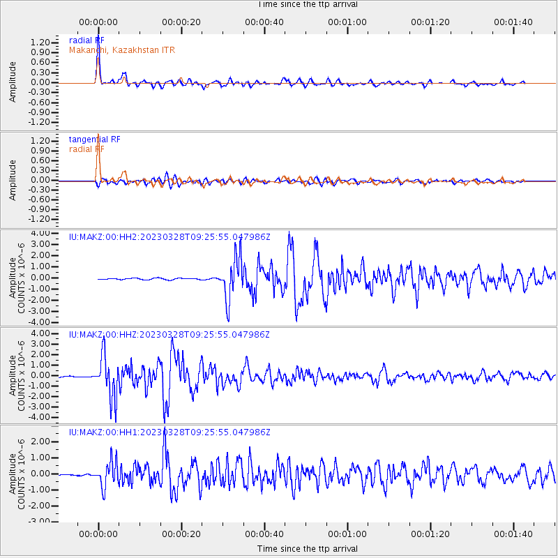
Signal To Noise
| Channel | StoN | STA | LTA |
| IU:MAKZ:00:HHZ:20230328T09:25:55.047986Z | 47.224014 | 2.0031205E-6 | 4.2417412E-8 |
| IU:MAKZ:00:HH1:20230328T09:25:55.047986Z | 18.093584 | 7.992517E-7 | 4.4173213E-8 |
| IU:MAKZ:00:HH2:20230328T09:25:55.047986Z | 30.77105 | 1.8913767E-6 | 6.146611E-8 |
| Arrivals |
| Ps | 6.0 SECOND |
| PpPs | 19 SECOND |
| PsPs/PpSs | 25 SECOND |


