You are here: Home > Network List > CI - Caltech Regional Seismic Network Stations List
> Station MUR Murrieta > Earthquake Result Viewer
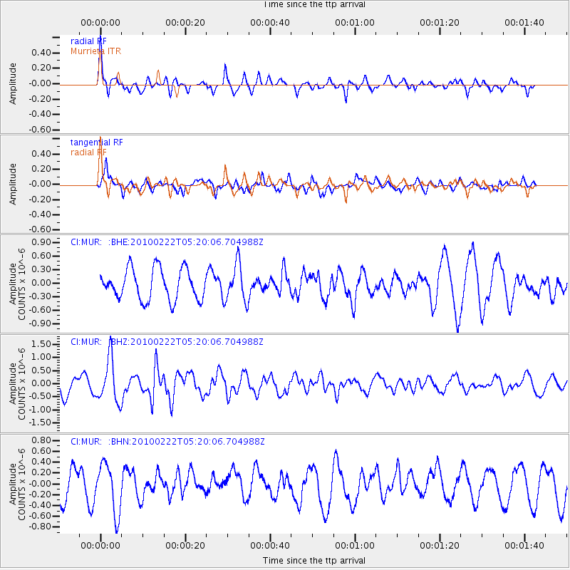
MUR Murrieta - Earthquake Result Viewer
*The percent match for this event was below the threshold and hence no stack was calculated.
| Earthquake location: |
Tonga Islands |
| Earthquake latitude/longitude: |
-21.5/-173.8 |
| Earthquake time(UTC): |
2010/02/22 (053) 05:08:49 GMT |
| Earthquake Depth: |
33 km |
| Earthquake Magnitude: |
5.8 MB, 5.3 MS, 5.7 MW, 5.7 MW |
| Earthquake Catalog/Contributor: |
WHDF/NEIC |
|
| Network: |
CI Caltech Regional Seismic Network |
| Station: |
MUR Murrieta |
| Lat/Lon: |
33.60 N/117.20 W |
| Elevation: |
562 m |
|
| Distance: |
76.9 deg |
| Az: |
45.673 deg |
| Baz: |
232.951 deg |
| Ray Param: |
$rayparam |
*The percent match for this event was below the threshold and hence was not used in the summary stack. |
|
| Radial Match: |
56.17047 % |
| Radial Bump: |
365 |
| Transverse Match: |
52.20561 % |
| Transverse Bump: |
400 |
| SOD ConfigId: |
307546 |
| Insert Time: |
2010-05-14 06:42:10.833 +0000 |
| GWidth: |
2.5 |
| Max Bumps: |
400 |
| Tol: |
0.001 |
|
Signal To Noise
| Channel | StoN | STA | LTA |
| CI:MUR: :BHZ:20100222T05:20:06.704988Z | 2.7232485 | 8.356948E-7 | 3.0687423E-7 |
| CI:MUR: :BHN:20100222T05:20:06.704988Z | 1.7199044 | 4.6496163E-7 | 2.7034153E-7 |
| CI:MUR: :BHE:20100222T05:20:06.704988Z | 1.2623937 | 4.2590648E-7 | 3.3738007E-7 |
| Arrivals |
| Ps | |
| PpPs | |
| PsPs/PpSs | |


