You are here: Home > Network List > ND - New CaleDonia Broadband Seismic Network Stations List
> Station KOUNC Koumac, New Caledonia > Earthquake Result Viewer
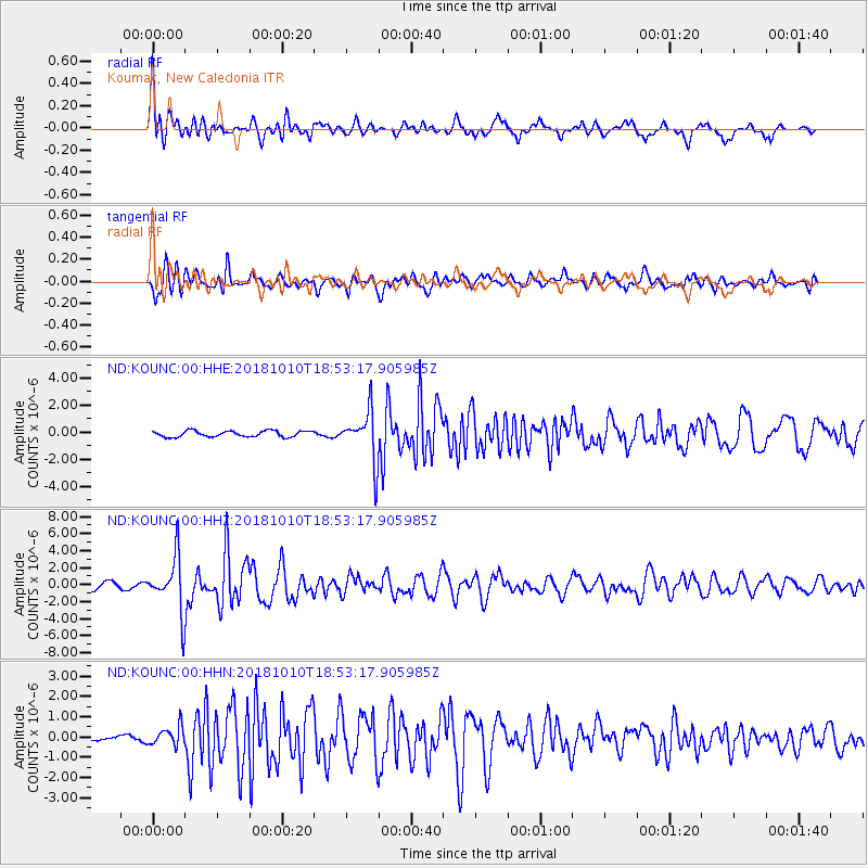
KOUNC Koumac, New Caledonia - Earthquake Result Viewer

| Earthquake location: |
Bali Sea |
| Earthquake latitude/longitude: |
-7.4/114.5 |
| Earthquake time(UTC): |
2018/10/10 (283) 18:44:55 GMT |
| Earthquake Depth: |
10 km |
| Earthquake Magnitude: |
6.0 Mww |
| Earthquake Catalog/Contributor: |
NEIC PDE/us |
|
| Network: |
ND New CaleDonia Broadband Seismic Network |
| Station: |
KOUNC Koumac, New Caledonia |
| Lat/Lon: |
20.55 S/164.29 E |
| Elevation: |
88 m |
|
| Distance: |
49.9 deg |
| Az: |
110.533 deg |
| Baz: |
277.705 deg |
| Ray Param: |
0.06841753 |
| Estimated Moho Depth: |
10.75 km |
| Estimated Crust Vp/Vs: |
2.10 |
| Assumed Crust Vp: |
5.14 km/s |
| Estimated Crust Vs: |
2.451 km/s |
| Estimated Crust Poisson's Ratio: |
0.35 |
|
| Radial Match: |
82.385666 % |
| Radial Bump: |
400 |
| Transverse Match: |
79.657745 % |
| Transverse Bump: |
400 |
| SOD ConfigId: |
3045211 |
| Insert Time: |
2018-10-24 18:48:49.462 +0000 |
| GWidth: |
2.5 |
| Max Bumps: |
400 |
| Tol: |
0.001 |
|
Signal To Noise
| Channel | StoN | STA | LTA |
| ND:KOUNC:00:HHZ:20181010T18:53:17.905985Z | 6.4526215 | 3.2740684E-6 | 5.0740124E-7 |
| ND:KOUNC:00:HHN:20181010T18:53:17.905985Z | 2.2544749 | 4.7089554E-7 | 2.0887151E-7 |
| ND:KOUNC:00:HHE:20181010T18:53:17.905985Z | 8.500722 | 1.8927584E-6 | 2.2265856E-7 |
| Arrivals |
| Ps | 2.4 SECOND |
| PpPs | 6.3 SECOND |
| PsPs/PpSs | 8.6 SECOND |


