You are here: Home > Network List > PQ - Public Safety Geoscience Program Canadian Research Network (PSGP) Stations List
> Station OGILY Ogilvie Highway Yard, Yukon > Earthquake Result Viewer
OGILY Ogilvie Highway Yard, Yukon - Earthquake Result Viewer
| Earthquake location: |
Hokkaido, Japan Region |
| Earthquake latitude/longitude: |
41.1/142.8 |
| Earthquake time(UTC): |
2023/03/28 (087) 09:18:27 GMT |
| Earthquake Depth: |
31 km |
| Earthquake Magnitude: |
6.2 Mww |
| Earthquake Catalog/Contributor: |
NEIC PDE/us |
|
| Network: |
PQ Public Safety Geoscience Program Canadian Research Network (PSGP) |
| Station: |
OGILY Ogilvie Highway Yard, Yukon |
| Lat/Lon: |
65.36 N/138.31 W |
| Elevation: |
602 m |
|
| Distance: |
49.0 deg |
| Az: |
33.03 deg |
| Baz: |
280.902 deg |
| Ray Param: |
0.06893119 |
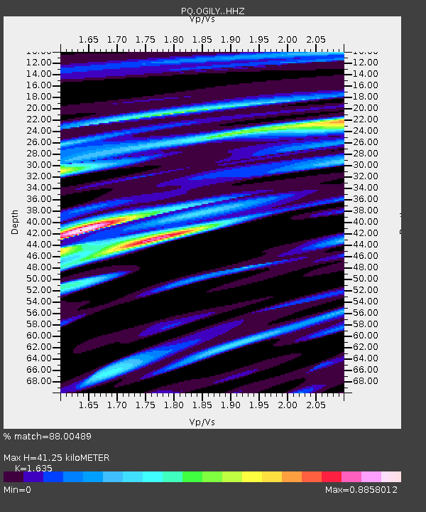
| Estimated Moho Depth: |
41.25 km |
| Estimated Crust Vp/Vs: |
1.63 |
| Assumed Crust Vp: |
6.566 km/s |
| Estimated Crust Vs: |
4.016 km/s |
| Estimated Crust Poisson's Ratio: |
0.20 |
|
| Radial Match: |
88.00489 % |
| Radial Bump: |
400 |
| Transverse Match: |
74.19972 % |
| Transverse Bump: |
400 |
| SOD ConfigId: |
30536071 |
| Insert Time: |
2023-04-11 09:43:35.948 +0000 |
| GWidth: |
2.5 |
| Max Bumps: |
400 |
| Tol: |
0.001 |
|

Signal To Noise
| Channel | StoN | STA | LTA |
| PQ:OGILY: :HHZ:20230328T09:26:40.81001Z | 8.942525 | 7.5579305E-7 | 8.4516735E-8 |
| PQ:OGILY: :HHN:20230328T09:26:40.81001Z | 1.4047812 | 2.265333E-7 | 1.6125877E-7 |
| PQ:OGILY: :HHE:20230328T09:26:40.81001Z | 5.6919312 | 5.8057566E-7 | 1.01999774E-7 |
| Arrivals |
| Ps | 4.3 SECOND |
| PpPs | 15 SECOND |
| PsPs/PpSs | 20 SECOND |


